La Pendencia geodata
La Pendencia (Zacatecas) is a populated place; located in Mexico in America/Mexico_City (GMT-6) time zone. With population of 1,121 people, there are 7740 cities with bigger population in this country. Compared to other cities in Mexico, 86.5% of cities are located further ↓South; 78% of cities are located further →East and 82.2% of cities have lower elevation than La Pendencia. Note1


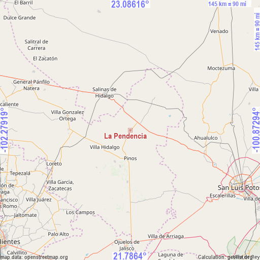
La Pendencia GPS coordinates[2]
22° 26' 16.08" North, 101° 34' 33.816" West
| Map corner | latitude | longitude |
|---|---|---|
| Upper-left | 23.08616°, | -102.27919° |
| Center: | 22.4378°, | -101.57606° |
| Lower-right: | 21.7864°, | -100.87294° |
| Map W x H: | 144.5×144.5 km | = 89.8×89.8mi |
| max Lat: | 32.7° ⇑13.5% North |
| La Pendencia: | 22.4378° |
| min Lat: | ⇓86.5% South 14.53588° |
| min Long | La Pendencia | max Long |
| -117.105° | -101.57606° | -86.73105° |
| W 22%⇐ | ⇒78% E |
Elevation
Elevation of La Pendencia is 2193 m = 7195 ft, and this is 939.3 m = 3082 ft above average elevation for this country.
| Max E: |
3497 m = 11473 ft | 17.8% |
| La Pendencia | 2193 m 7195 ft | |
| Avg. | 1253.7 m = 4113 ft | |
Min E: |
-1 m = -3 ft | 82.2% |
See also: Mexico elevation on elevation.city.
Geographical zone
La Pendencia is located in North Torrid zone (between Equator and Tropic of Cancer). Distance of this Northern Tropic circle is 111.1 km =69 mi to North.| Distance of | km | miles | from La Pendencia |
|---|---|---|---|
| North Pole | 7512.2 | 4667.9 | to North |
| Arctic Circle | 4906.3 | 3048.6 | to North |
| Tropic Cancer | 111.1 | 69 | to North |
| Equator | 2494.8 | 1550.2 | to South |


Nearby cities:
15 places around La Pendencia: (largest is in red/bold)
• Ahijaderos
13 km =8.1 mi,  125°
125°
• Caballerías (Caballería Villa Hidalgo)
9.8 km =6.1 mi,  233°
233°
• El Chino
15.7 km =9.8 mi,  212°
212°
• El Tepetate
14 km =8.7 mi,  249°
249°
• Estancia de Guadalupe
19.4 km =12.1 mi, 205°
• Guadalupe de los Sauces
16.1 km =10 mi,  123°
123°
• La Ballena
13.7 km =8.5 mi,  278°
278°
• Pinos
15.8 km =9.8 mi,  179°
179°
• Presa de Valenzuela
14 km =8.7 mi,  224°
224°
• Saldaña
18.5 km =11.5 mi,  103°
103°
• San Andrés
3.5 km =2.2 mi, 211°
• Santa Ana
11.7 km =7.3 mi, 115°
• Santiago
12.2 km =7.6 mi,  81°
81°
• Trinidad Norte
6.5 km =4 mi,  70°
70°
• Villa Hidalgo
16.7 km =10.4 mi,  237°
237°
Sources, notices
• [Note1] Compared only with cities in Mexico existing in our database
• [Src1] Map data: © OpenStreetMap contributors (CC-BY-SA)
• [Src2] Other city data from geonames.org with taken over terms of usage.
• [Src3] Geographical zone / Annual Mean Temperature by Robert A. Rohde @ Wikipedia
