Mascota geodata
Mascota (Jalisco) is a seat of a second-order administrative division; located in Mexico in America/Mexico_City (GMT-6) time zone. With population of 8,801 people, there are 1078 cities with bigger population in this country. Compared to other cities in Mexico, 68.3% of cities are located further ↓South; 91.6% of cities are located further →East and 54% of cities have higher elevation than Mascota. Note1


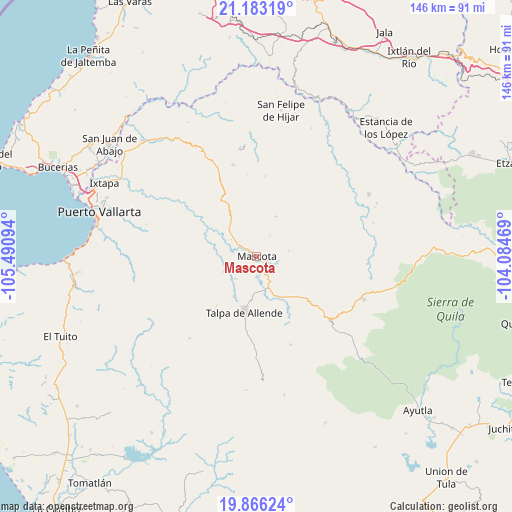
Mascota GPS coordinates[2]
20° 31' 34.068" North, 104° 47' 16.116" West
| Map corner | latitude | longitude |
|---|---|---|
| Upper-left | 21.18319°, | -105.49094° |
| Center: | 20.52613°, | -104.78781° |
| Lower-right: | 19.86624°, | -104.08469° |
| Map W x H: | 146.4×146.4 km | = 91×91mi |
| max Lat: | 32.7° ⇑31.7% North |
| Mascota: | 20.52613° |
| min Lat: | ⇓68.3% South 14.53588° |
| min Long | Mascota | max Long |
| -117.105° | -104.78781° | -86.73105° |
| W 8.4%⇐ | ⇒91.6% E |
Elevation
Elevation of Mascota is 1239 m = 4065 ft, and this is 14.7 m = 48 ft below average elevation for this country.
| Max E: |
3497 m = 11473 ft | 54% |
| Avg. | 1253.7 m = 4113 ft | |
| Mascota | 1239 m = 4065 ft | |
Min E: |
-1 m = -3 ft | 46% |
See also: Mexico elevation on elevation.city.
Geographical zone
Mascota is located in North Torrid zone (between Equator and Tropic of Cancer). Distance of this Northern Tropic circle is 323.6 km =201.1 mi to North.| Distance of | km | miles | from Mascota |
|---|---|---|---|
| North Pole | 7724.8 | 4800 | to North |
| Arctic Circle | 5118.9 | 3180.7 | to North |
| Tropic Cancer | 323.6 | 201.1 | to North |
| Equator | 2282.3 | 1418.2 | to South |


Nearby cities:
15 places around Mascota: (largest is in red/bold)
• Atenguillo
33 km =20.5 mi,  111°
111°
• El Colorado
47 km =29.2 mi,  305°
305°
• El Ranchito
44.1 km =27.4 mi,  301°
301°
• El Salto
36.9 km =22.9 mi,  125°
125°
• Guachinango
42.8 km =26.6 mi,  82°
82°
• La Desembocada
44.4 km =27.6 mi, 300°
• La Laja
28.1 km =17.5 mi, 76°
• Los Volcanes
34.3 km =21.3 mi, 130°
• Mixtlán
40.7 km =25.3 mi,  103°
103°
• Ocotes
13.3 km =8.3 mi,  209°
209°
• Puerto Vallarta
47.1 km =29.3 mi,  282°
282°
• San Felipe de Híjar
42.3 km =26.3 mi,  9°
9°
• San Sebastián del Oeste
27.1 km =16.8 mi,  345°
345°
• Santiago de Pinos
31.5 km =19.6 mi, 351°
• Talpa de Allende
16.5 km =10.3 mi,  192°
192°
Sources, notices
• [Note1] Compared only with cities in Mexico existing in our database
• [Src1] Map data: © OpenStreetMap contributors (CC-BY-SA)
• [Src2] Other city data from geonames.org with taken over terms of usage.
• [Src3] Geographical zone / Annual Mean Temperature by Robert A. Rohde @ Wikipedia
