Talpa de Allende geodata
Talpa de Allende (Jalisco) is a seat of a second-order administrative division; located in Mexico in America/Mexico_City (GMT-6) time zone. With population of 8,839 people, there are 1072 cities with bigger population in this country. Compared to other cities in Mexico, 65.2% of cities are located further ↓South; 91.6% of cities are located further →East and 56% of cities have higher elevation than Talpa de Allende. Note1


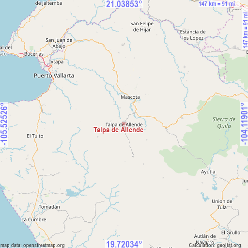
Talpa de Allende GPS coordinates[2]
20° 22' 51.024" North, 104° 49' 19.668" West
| Map corner | latitude | longitude |
|---|---|---|
| Upper-left | 21.03853°, | -105.52526° |
| Center: | 20.38084°, | -104.82213° |
| Lower-right: | 19.72034°, | -104.11901° |
| Map W x H: | 146.6×146.6 km | = 91.1×91.1mi |
| max Lat: | 32.7° ⇑34.8% North |
| Talpa de Allende: | 20.38084° |
| min Lat: | ⇓65.2% South 14.53588° |
| min Long | Talpa de Allend | max Long |
| -117.105° | -104.82213° | -86.73105° |
| W 8.4%⇐ | ⇒91.6% E |
Elevation
Elevation of Talpa de Allende is 1159 m = 3802 ft, and this is 94.7 m = 311 ft below average elevation for this country.
| Max E: |
3497 m = 11473 ft | 56% |
| Avg. | 1253.7 m = 4113 ft | |
| Talpa de Allende | 1159 m = 3802 ft | |
Min E: |
-1 m = -3 ft | 44% |
See also: Mexico elevation on elevation.city.
Geographical zone
Talpa de Allende is located in North Torrid zone (between Equator and Tropic of Cancer). Distance of this Northern Tropic circle is 339.8 km =211.1 mi to North.| Distance of | km | miles | from Talpa de Allende |
|---|---|---|---|
| North Pole | 7740.9 | 4810 | to North |
| Arctic Circle | 5135 | 3190.7 | to North |
| Tropic Cancer | 339.8 | 211.1 | to North |
| Equator | 2266.1 | 1408.1 | to South |


Nearby cities:
15 places around Talpa de Allende: (largest is in red/bold)
• Atenguillo
34.4 km =21.4 mi,  83°
83°
• Cuautla
47.6 km =29.6 mi,  114°
114°
• El Salto
34 km =21.1 mi,  98°
98°
• Guachinango
50.9 km =31.6 mi,  64°
64°
• La Laja
38.4 km =23.9 mi,  53°
53°
• Las Juntas y los Veranos
50.5 km =31.4 mi,  282°
282°
• Llano Grande
38.8 km =24.1 mi,  188°
188°
• Los Volcanes
30.2 km =18.8 mi, 102°
• Mascota
16.5 km =10.3 mi,  12°
12°
• Mixtlán
43.6 km =27.1 mi, 81°
• Ocotes
5.6 km =3.5 mi,  326°
326°
• Puerto Vallarta
50 km =31.1 mi,  301°
301°
• San Rafael de los Moreno
48.5 km =30.1 mi,  233°
233°
• San Sebastián del Oeste
42.5 km =26.4 mi,  355°
355°
• Santiago de Pinos
47.3 km =29.4 mi, 358°
Sources, notices
• [Note1] Compared only with cities in Mexico existing in our database
• [Src1] Map data: © OpenStreetMap contributors (CC-BY-SA)
• [Src2] Other city data from geonames.org with taken over terms of usage.
• [Src3] Geographical zone / Annual Mean Temperature by Robert A. Rohde @ Wikipedia
