El Limón geodata
El Limón (Michoacán) is a populated place; located in Mexico in America/Mexico_City (GMT-6) time zone. With population of 794 people, there are 10982 cities with bigger population in this country. Compared to other cities in Mexico, 60.2% of cities are located further ↓South; 83.6% of cities are located further →East and 53.2% of cities have lower elevation than El Limón. Note1


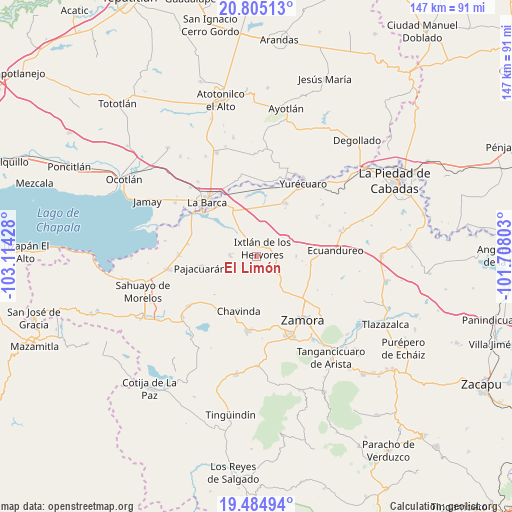
El Limón GPS coordinates[2]
20° 8' 47.148" North, 102° 24' 40.14" West
| Map corner | latitude | longitude |
|---|---|---|
| Upper-left | 20.80513°, | -103.11428° |
| Center: | 20.14643°, | -102.41115° |
| Lower-right: | 19.48494°, | -101.70803° |
| Map W x H: | 146.8×146.8 km | = 91.2×91.2mi |
| max Lat: | 32.7° ⇑39.8% North |
| El Limón: | 20.14643° |
| min Lat: | ⇓60.2% South 14.53588° |
| min Long | El Limón | max Long |
| -117.105° | -102.41115° | -86.73105° |
| W 16.4%⇐ | ⇒83.6% E |
Elevation
Elevation of El Limón is 1544 m = 5066 ft, and this is 290.3 m = 952 ft above average elevation for this country.
| Max E: |
3497 m = 11473 ft | 46.8% |
| El Limón | 1544 m 5066 ft | |
| Avg. | 1253.7 m = 4113 ft | |
Min E: |
-1 m = -3 ft | 53.2% |
See also: Mexico elevation on elevation.city.
Geographical zone
El Limón is located in North Torrid zone (between Equator and Tropic of Cancer). Distance of this Northern Tropic circle is 365.8 km =227.3 mi to North.| Distance of | km | miles | from El Limón |
|---|---|---|---|
| North Pole | 7767 | 4826.2 | to North |
| Arctic Circle | 5161.1 | 3207 | to North |
| Tropic Cancer | 365.8 | 227.3 | to North |
| Equator | 2240.1 | 1391.9 | to South |


Nearby cities:
15 places around El Limón: (largest is in red/bold)
• Camucuato
3.7 km =2.3 mi,  327°
327°
• El Colesio
11.5 km =7.1 mi,  89°
89°
• El Colongo
6.3 km =3.9 mi,  139°
139°
• El Salitre
4.4 km =2.7 mi,  58°
58°
• El Tepehuaje
8.5 km =5.3 mi,  171°
171°
• El Valenciano
4.8 km =3 mi,  273°
273°
• Ixtlán de los Hervores
3 km =1.9 mi,  34°
34°
• La Angostura
6.4 km =4 mi, 330°
• La Esperanza
10.1 km =6.3 mi,  179°
179°
• La Estanzuela
5.3 km =3.3 mi,  124°
124°
• La Luz
7.8 km =4.8 mi, 274°
• La Plaza del Limón
2.4 km =1.5 mi,  239°
239°
• La Sauceda
9 km =5.6 mi,  130°
130°
• Rincón del Mezquite
5.9 km =3.7 mi,  188°
188°
• Tecomatán
9.5 km =5.9 mi,  248°
248°
Sources, notices
• [Note1] Compared only with cities in Mexico existing in our database
• [Src1] Map data: © OpenStreetMap contributors (CC-BY-SA)
• [Src2] Other city data from geonames.org with taken over terms of usage.
• [Src3] Geographical zone / Annual Mean Temperature by Robert A. Rohde @ Wikipedia
