La Angostura geodata
La Angostura (Michoacán) is a populated place; located in Mexico in America/Mexico_City (GMT-6) time zone. With population of 1,467 people, there are 5888 cities with bigger population in this country. Compared to other cities in Mexico, 61.2% of cities are located further ↓South; 83.8% of cities are located further →East and 52.9% of cities have lower elevation than La Angostura. Note1


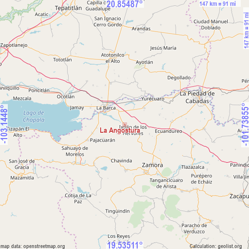
La Angostura GPS coordinates[2]
20° 11' 47.004" North, 102° 26' 30.012" West
| Map corner | latitude | longitude |
|---|---|---|
| Upper-left | 20.85487°, | -103.1448° |
| Center: | 20.19639°, | -102.44167° |
| Lower-right: | 19.53511°, | -101.73855° |
| Map W x H: | 146.7×146.7 km | = 91.2×91.2mi |
| max Lat: | 32.7° ⇑38.8% North |
| La Angostura: | 20.19639° |
| min Lat: | ⇓61.2% South 14.53588° |
| min Long | La Angostura | max Long |
| -117.105° | -102.44167° | -86.73105° |
| W 16.2%⇐ | ⇒83.8% E |
Elevation
Elevation of La Angostura is 1540 m = 5052 ft, and this is 286.3 m = 939 ft above average elevation for this country.
| Max E: |
3497 m = 11473 ft | 47.1% |
| La Angostura | 1540 m 5052 ft | |
| Avg. | 1253.7 m = 4113 ft | |
Min E: |
-1 m = -3 ft | 52.9% |
See also: Mexico elevation on elevation.city.
Geographical zone
La Angostura is located in North Torrid zone (between Equator and Tropic of Cancer). Distance of this Northern Tropic circle is 360.3 km =223.9 mi to North.| Distance of | km | miles | from La Angostura |
|---|---|---|---|
| North Pole | 7761.4 | 4822.7 | to North |
| Arctic Circle | 5155.5 | 3203.5 | to North |
| Tropic Cancer | 360.3 | 223.9 | to North |
| Equator | 2245.6 | 1395.4 | to South |


Nearby cities:
15 places around La Angostura: (largest is in red/bold)
• Camucuato
2.7 km =1.7 mi,  154°
154°
• El Alvareño
11.6 km =7.2 mi,  2°
2°
• El Capulín
6.1 km =3.8 mi,  304°
304°
• El Limón
6.4 km =4 mi, 150°
• El Salitre
7.7 km =4.8 mi,  114°
114°
• El Valenciano
5.5 km =3.4 mi,  196°
196°
• Ixtlán de los Hervores
5.8 km =3.6 mi,  121°
121°
• La Estanzuela
11.4 km =7.1 mi,  138°
138°
• La Luz
6.7 km =4.2 mi,  222°
222°
• La Plaza del Limón
6.9 km =4.3 mi,  170°
170°
• Los Charcos
8.4 km =5.2 mi,  24°
24°
• Rincón del Mezquite
11.6 km =7.2 mi, 168°
• San Gregorio
11.2 km =7 mi,  269°
269°
• Tecomatán
10.7 km =6.6 mi,  212°
212°
• Vista Hermosa de Negrete
9.1 km =5.7 mi,  337°
337°
Sources, notices
• [Note1] Compared only with cities in Mexico existing in our database
• [Src1] Map data: © OpenStreetMap contributors (CC-BY-SA)
• [Src2] Other city data from geonames.org with taken over terms of usage.
• [Src3] Geographical zone / Annual Mean Temperature by Robert A. Rohde @ Wikipedia
