Rincón del Mezquite geodata
Rincón del Mezquite (Michoacán) is a populated place; located in Mexico in America/Mexico_City (GMT-6) time zone. With population of 557 people, there are 15314 cities with bigger population in this country. Compared to other cities in Mexico, 59% of cities are located further ↓South; 83.6% of cities are located further →East and 54.8% of cities have lower elevation than Rincón del Mezquite. Note1


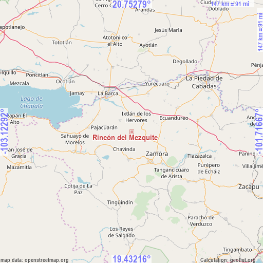
Rincón del Mezquite GPS coordinates[2]
20° 5' 37.932" North, 102° 25' 11.244" West
| Map corner | latitude | longitude |
|---|---|---|
| Upper-left | 20.75279°, | -103.12292° |
| Center: | 20.09387°, | -102.41979° |
| Lower-right: | 19.43216°, | -101.71667° |
| Map W x H: | 146.8×146.8 km | = 91.2×91.2mi |
| max Lat: | 32.7° ⇑41% North |
| Rincón del Mezquite: | 20.09387° |
| min Lat: | ⇓59% South 14.53588° |
| min Long | Rincón del Mez | max Long |
| -117.105° | -102.41979° | -86.73105° |
| W 16.4%⇐ | ⇒83.6% E |
Elevation
Elevation of Rincón del Mezquite is 1584 m = 5197 ft, and this is 330.3 m = 1084 ft above average elevation for this country.
| Max E: |
3497 m = 11473 ft | 45.2% |
| Rincón del Mezquite | 1584 m 5197 ft | |
| Avg. | 1253.7 m = 4113 ft | |
Min E: |
-1 m = -3 ft | 54.8% |
See also: Mexico elevation on elevation.city.
Geographical zone
Rincón del Mezquite is located in North Torrid zone (between Equator and Tropic of Cancer). Distance of this Northern Tropic circle is 371.7 km =231 mi to North.| Distance of | km | miles | from Rincón del Mezquite |
|---|---|---|---|
| North Pole | 7772.8 | 4829.8 | to North |
| Arctic Circle | 5166.9 | 3210.6 | to North |
| Tropic Cancer | 371.7 | 231 | to North |
| Equator | 2234.2 | 1388.3 | to South |


Nearby cities:
15 places around Rincón del Mezquite: (largest is in red/bold)
• Camucuato
9 km =5.6 mi,  352°
352°
• El Colongo
5.1 km =3.2 mi,  78°
78°
• El Limón
5.9 km =3.7 mi,  8°
8°
• El Llano
8.2 km =5.1 mi,  148°
148°
• El Salitre
9.4 km =5.8 mi,  30°
30°
• El Tepehuaje
3.4 km =2.1 mi,  139°
139°
• El Valenciano
7.2 km =4.5 mi,  327°
327°
• Ixtlán de los Hervores
8.7 km =5.4 mi,  17°
17°
• La Cuestita
8.1 km =5 mi,  246°
246°
• La Esperanza
4.4 km =2.7 mi,  167°
167°
• La Estanzuela
6 km =3.7 mi,  61°
61°
• La Luz
9.4 km =5.8 mi,  313°
313°
• La Plaza del Limón
4.8 km =3 mi, 345°
• La Sauceda
7.8 km =4.8 mi,  89°
89°
• Tecomatán
8.3 km =5.2 mi,  286°
286°
Sources, notices
• [Note1] Compared only with cities in Mexico existing in our database
• [Src1] Map data: © OpenStreetMap contributors (CC-BY-SA)
• [Src2] Other city data from geonames.org with taken over terms of usage.
• [Src3] Geographical zone / Annual Mean Temperature by Robert A. Rohde @ Wikipedia
