Camucuato geodata
Camucuato (Michoacán) is a populated place; located in Mexico in America/Mexico_City (GMT-6) time zone. With population of 561 people, there are 15205 cities with bigger population in this country. Compared to other cities in Mexico, 60.8% of cities are located further ↓South; 83.7% of cities are located further →East and 52.9% of cities have lower elevation than Camucuato. Note1


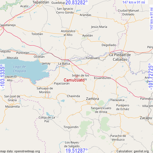
Camucuato GPS coordinates[2]
20° 10' 27.264" North, 102° 25' 49.332" West
| Map corner | latitude | longitude |
|---|---|---|
| Upper-left | 20.83282°, | -103.1335° |
| Center: | 20.17424°, | -102.43037° |
| Lower-right: | 19.51287°, | -101.72725° |
| Map W x H: | 146.8×146.8 km | = 91.2×91.2mi |
| max Lat: | 32.7° ⇑39.2% North |
| Camucuato: | 20.17424° |
| min Lat: | ⇓60.8% South 14.53588° |
| min Long | Camucuato | max Long |
| -117.105° | -102.43037° | -86.73105° |
| W 16.3%⇐ | ⇒83.7% E |
Elevation
Elevation of Camucuato is 1539 m = 5049 ft, and this is 285.3 m = 936 ft above average elevation for this country.
| Max E: |
3497 m = 11473 ft | 47.1% |
| Camucuato | 1539 m 5049 ft | |
| Avg. | 1253.7 m = 4113 ft | |
Min E: |
-1 m = -3 ft | 52.9% |
See also: Mexico elevation on elevation.city.
Geographical zone
Camucuato is located in North Torrid zone (between Equator and Tropic of Cancer). Distance of this Northern Tropic circle is 362.8 km =225.4 mi to North.| Distance of | km | miles | from Camucuato |
|---|---|---|---|
| North Pole | 7763.9 | 4824.3 | to North |
| Arctic Circle | 5158 | 3205 | to North |
| Tropic Cancer | 362.8 | 225.4 | to North |
| Equator | 2243.2 | 1393.9 | to South |


Nearby cities:
15 places around Camucuato: (largest is in red/bold)
• El Capulín
8.6 km =5.3 mi,  313°
313°
• El Colongo
10 km =6.2 mi,  142°
142°
• El Limón
3.7 km =2.3 mi,  147°
147°
• El Salitre
5.9 km =3.7 mi,  97°
97°
• El Tepehuaje
12 km =7.5 mi,  163°
163°
• El Valenciano
4 km =2.5 mi,  224°
224°
• Ixtlán de los Hervores
3.8 km =2.4 mi, 99°
• La Angostura
2.7 km =1.7 mi,  334°
334°
• La Estanzuela
8.8 km =5.5 mi,  133°
133°
• La Luz
6.2 km =3.9 mi,  246°
246°
• La Plaza del Limón
4.3 km =2.7 mi,  181°
181°
• Los Charcos
10.3 km =6.4 mi,  12°
12°
• Rincón del Mezquite
9 km =5.6 mi,  172°
172°
• Tecomatán
9.5 km =5.9 mi,  226°
226°
• Vista Hermosa de Negrete
11.8 km =7.3 mi,  336°
336°
Sources, notices
• [Note1] Compared only with cities in Mexico existing in our database
• [Src1] Map data: © OpenStreetMap contributors (CC-BY-SA)
• [Src2] Other city data from geonames.org with taken over terms of usage.
• [Src3] Geographical zone / Annual Mean Temperature by Robert A. Rohde @ Wikipedia
