Guadalcázar geodata
Guadalcázar (San Luis Potosí) is a seat of a second-order administrative division; located in Mexico in America/Mexico_City (GMT-6) time zone. With population of 1,209 people, there are 7199 cities with bigger population in this country. Compared to other cities in Mexico, 87.1% of cities are located further ↓South; 68.4% of cities are located further →East and 56.9% of cities have lower elevation than Guadalcázar. Note1


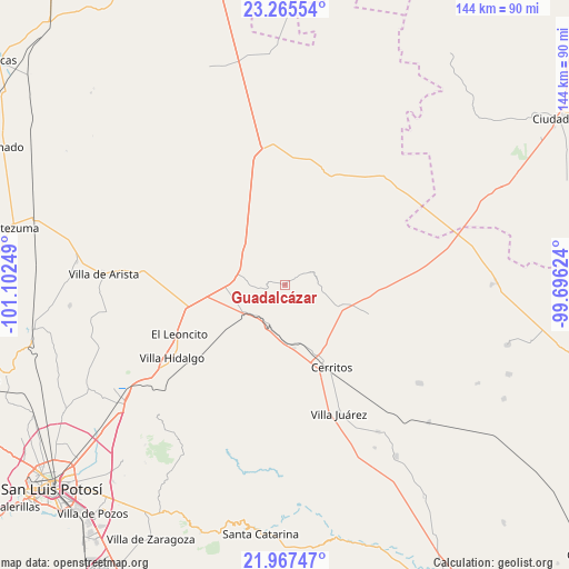
Guadalcázar GPS coordinates[2]
22° 37' 4.944" North, 100° 23' 57.696" West
| Map corner | latitude | longitude |
|---|---|---|
| Upper-left | 23.26554°, | -101.10249° |
| Center: | 22.61804°, | -100.39936° |
| Lower-right: | 21.96747°, | -99.69624° |
| Map W x H: | 144.3×144.3 km | = 89.7×89.7mi |
| max Lat: | 32.7° ⇑12.9% North |
| Guadalcázar: | 22.61804° |
| min Lat: | ⇓87.1% South 14.53588° |
| min Long | Guadalcázar | max Long |
| -117.105° | -100.39936° | -86.73105° |
| W 31.6%⇐ | ⇒68.4% E |
Elevation
Elevation of Guadalcázar is 1655 m = 5430 ft, and this is 401.3 m = 1317 ft above average elevation for this country.
| Max E: |
3497 m = 11473 ft | 43.1% |
| Guadalcázar | 1655 m 5430 ft | |
| Avg. | 1253.7 m = 4113 ft | |
Min E: |
-1 m = -3 ft | 56.9% |
See also: Mexico elevation on elevation.city.
Geographical zone
Guadalcázar is located in North Torrid zone (between Equator and Tropic of Cancer). Distance of this Northern Tropic circle is 91 km =56.5 mi to North.| Distance of | km | miles | from Guadalcázar |
|---|---|---|---|
| North Pole | 7492.2 | 4655.4 | to North |
| Arctic Circle | 4886.3 | 3036.2 | to North |
| Tropic Cancer | 91 | 56.5 | to North |
| Equator | 2514.9 | 1562.7 | to South |


Nearby cities:
15 places around Guadalcázar: (largest is in red/bold)
• Abrego
3.5 km =2.2 mi,  46°
46°
• Buenavista
26.4 km =16.4 mi,  94°
94°
• Cerritos
24.2 km =15 mi,  150°
150°
• Charco Blanco
12.5 km =7.8 mi,  277°
277°
• Derramaderos
17.2 km =10.7 mi,  131°
131°
• El Charquito
30.2 km =18.8 mi,  272°
272°
• El Quelital
22.4 km =13.9 mi,  109°
109°
• Joya de Luna
20.5 km =12.7 mi,  186°
186°
• La Hincada
30.4 km =18.9 mi,  81°
81°
• Núñez
13.5 km =8.4 mi,  305°
305°
• Peotillos
25.8 km =16 mi,  237°
237°
• Peyote
21.5 km =13.4 mi, 281°
• Pozas de Santa Ana
22 km =13.7 mi,  344°
344°
• San Lorenzo
26.3 km =16.3 mi,  255°
255°
• Santo Domingo
30 km =18.6 mi,  23°
23°
Sources, notices
• [Note1] Compared only with cities in Mexico existing in our database
• [Src1] Map data: © OpenStreetMap contributors (CC-BY-SA)
• [Src2] Other city data from geonames.org with taken over terms of usage.
• [Src3] Geographical zone / Annual Mean Temperature by Robert A. Rohde @ Wikipedia
