Cerritos geodata
Cerritos (San Luis Potosí) is a seat of a second-order administrative division; located in Mexico in America/Mexico_City (GMT-6) time zone. With population of 14,804 people, there are 655 cities with bigger population in this country. Compared to other cities in Mexico, 86.4% of cities are located further ↓South; 67.2% of cities are located further →East and 56.4% of cities have higher elevation than Cerritos. Note1


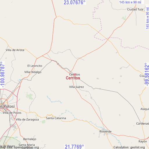
Cerritos GPS coordinates[2]
22° 25' 42.06" North, 100° 17' 5.064" West
| Map corner | latitude | longitude |
|---|---|---|
| Upper-left | 23.07676°, | -100.98787° |
| Center: | 22.42835°, | -100.28474° |
| Lower-right: | 21.7769°, | -99.58162° |
| Map W x H: | 144.5×144.5 km | = 89.8×89.8mi |
| max Lat: | 32.7° ⇑13.6% North |
| Cerritos: | 22.42835° |
| min Lat: | ⇓86.4% South 14.53588° |
| min Long | Cerritos | max Long |
| -117.105° | -100.28474° | -86.73105° |
| W 32.8%⇐ | ⇒67.2% E |
Elevation
Elevation of Cerritos is 1145 m = 3757 ft, and this is 108.7 m = 357 ft below average elevation for this country.
| Max E: |
3497 m = 11473 ft | 56.4% |
| Avg. | 1253.7 m = 4113 ft | |
| Cerritos | 1145 m = 3757 ft | |
Min E: |
-1 m = -3 ft | 43.6% |
See also: Mexico elevation on elevation.city.
Geographical zone
Cerritos is located in North Torrid zone (between Equator and Tropic of Cancer). Distance of this Northern Tropic circle is 112.1 km =69.7 mi to North.| Distance of | km | miles | from Cerritos |
|---|---|---|---|
| North Pole | 7513.3 | 4668.5 | to North |
| Arctic Circle | 4907.4 | 3049.3 | to North |
| Tropic Cancer | 112.1 | 69.7 | to North |
| Equator | 2493.8 | 1549.6 | to South |


Nearby cities:
15 places around Cerritos: (largest is in red/bold)
• Abrego
25.2 km =15.7 mi,  338°
338°
• Buenavista
23.9 km =14.9 mi,  37°
37°
• Derramaderos
9.7 km =6 mi,  6°
6°
• El Quelital
16.4 km =10.2 mi,  34°
34°
• Granjenal
22.5 km =14 mi,  100°
100°
• Guadalcázar
24.2 km =15 mi,  330°
330°
• Joya de Luna
14.2 km =8.8 mi,  272°
272°
• La Hincada
31.5 km =19.6 mi, 35°
• Ojo de Agua
19.8 km =12.3 mi,  85°
85°
• Palo Seco (El Gato)
12.6 km =7.8 mi,  130°
130°
• Progreso
27.5 km =17.1 mi,  144°
144°
• Puerta del Río
21.1 km =13.1 mi,  173°
173°
• San Bartolo
28.4 km =17.6 mi,  119°
119°
• Santo Domingo
20 km =12.4 mi, 143°
• Villa Juárez
11.5 km =7.1 mi, 170°
Sources, notices
• [Note1] Compared only with cities in Mexico existing in our database
• [Src1] Map data: © OpenStreetMap contributors (CC-BY-SA)
• [Src2] Other city data from geonames.org with taken over terms of usage.
• [Src3] Geographical zone / Annual Mean Temperature by Robert A. Rohde @ Wikipedia
