Derramaderos geodata
Derramaderos (San Luis Potosí) is a populated place; located in Mexico in America/Mexico_City (GMT-6) time zone. With population of 566 people, there are 15096 cities with bigger population in this country. Compared to other cities in Mexico, 86.8% of cities are located further ↓South; 67.1% of cities are located further →East and 54.7% of cities have higher elevation than Derramaderos. Note1


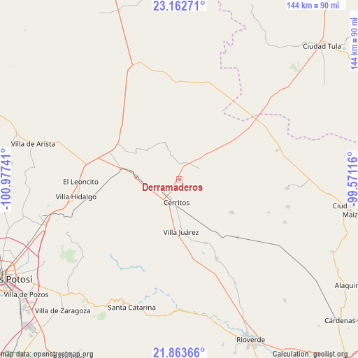
Derramaderos GPS coordinates[2]
22° 30' 52.956" North, 100° 16' 27.408" West
| Map corner | latitude | longitude |
|---|---|---|
| Upper-left | 23.16271°, | -100.97741° |
| Center: | 22.51471°, | -100.27428° |
| Lower-right: | 21.86366°, | -99.57116° |
| Map W x H: | 144.4×144.4 km | = 89.7×89.7mi |
| max Lat: | 32.7° ⇑13.2% North |
| Derramaderos: | 22.51471° |
| min Lat: | ⇓86.8% South 14.53588° |
| min Long | Derramaderos | max Long |
| -117.105° | -100.27428° | -86.73105° |
| W 32.9%⇐ | ⇒67.1% E |
Elevation
Elevation of Derramaderos is 1211 m = 3973 ft, and this is 42.7 m = 140 ft below average elevation for this country.
| Max E: |
3497 m = 11473 ft | 54.7% |
| Avg. | 1253.7 m = 4113 ft | |
| Derramaderos | 1211 m = 3973 ft | |
Min E: |
-1 m = -3 ft | 45.3% |
See also: Mexico elevation on elevation.city.
Geographical zone
Derramaderos is located in North Torrid zone (between Equator and Tropic of Cancer). Distance of this Northern Tropic circle is 102.5 km =63.7 mi to North.| Distance of | km | miles | from Derramaderos |
|---|---|---|---|
| North Pole | 7503.7 | 4662.6 | to North |
| Arctic Circle | 4897.8 | 3043.4 | to North |
| Tropic Cancer | 102.5 | 63.7 | to North |
| Equator | 2503.4 | 1555.5 | to South |


Nearby cities:
15 places around Derramaderos: (largest is in red/bold)
• Abrego
17.3 km =10.7 mi,  323°
323°
• Buenavista
16.4 km =10.2 mi,  55°
55°
• Cerritos
9.7 km =6 mi,  186°
186°
• Charco Blanco
28.5 km =17.7 mi,  297°
297°
• El Quelital
9.1 km =5.7 mi,  65°
65°
• Granjenal
25.1 km =15.6 mi,  122°
122°
• Guadalcázar
17.2 km =10.7 mi,  311°
311°
• Joya de Luna
17.6 km =10.9 mi,  239°
239°
• La Hincada
23.5 km =14.6 mi,  46°
46°
• Núñez
30.7 km =19.1 mi, 309°
• Ojo de Agua
20.2 km =12.6 mi,  112°
112°
• Palo Seco (El Gato)
19.8 km =12.3 mi,  154°
154°
• Puerta del Río
30.6 km =19 mi,  177°
177°
• Santo Domingo
27.9 km =17.3 mi,  157°
157°
• Villa Juárez
21 km =13 mi, 177°
Sources, notices
• [Note1] Compared only with cities in Mexico existing in our database
• [Src1] Map data: © OpenStreetMap contributors (CC-BY-SA)
• [Src2] Other city data from geonames.org with taken over terms of usage.
• [Src3] Geographical zone / Annual Mean Temperature by Robert A. Rohde @ Wikipedia
