Joya de Luna geodata
Joya de Luna (San Luis Potosí) is a populated place; located in Mexico in America/Mexico_City (GMT-6) time zone. With population of 565 people, there are 15122 cities with bigger population in this country. Compared to other cities in Mexico, 86.4% of cities are located further ↓South; 68.7% of cities are located further →East and 53.4% of cities have higher elevation than Joya de Luna. Note1


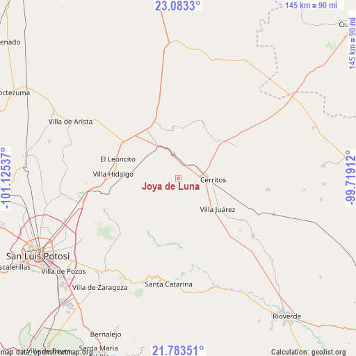
Joya de Luna GPS coordinates[2]
22° 26' 5.748" North, 100° 25' 20.064" West
| Map corner | latitude | longitude |
|---|---|---|
| Upper-left | 23.0833°, | -101.12537° |
| Center: | 22.43493°, | -100.42224° |
| Lower-right: | 21.78351°, | -99.71912° |
| Map W x H: | 144.5×144.5 km | = 89.8×89.8mi |
| max Lat: | 32.7° ⇑13.6% North |
| Joya de Luna: | 22.43493° |
| min Lat: | ⇓86.4% South 14.53588° |
| min Long | Joya de Luna | max Long |
| -117.105° | -100.42224° | -86.73105° |
| W 31.3%⇐ | ⇒68.7% E |
Elevation
Elevation of Joya de Luna is 1271 m = 4170 ft, and this is 17.3 m = 57 ft above average elevation for this country.
| Max E: |
3497 m = 11473 ft | 53.4% |
| Joya de Luna | 1271 m 4170 ft | |
| Avg. | 1253.7 m = 4113 ft | |
Min E: |
-1 m = -3 ft | 46.6% |
See also: Mexico elevation on elevation.city.
Geographical zone
Joya de Luna is located in North Torrid zone (between Equator and Tropic of Cancer). Distance of this Northern Tropic circle is 111.4 km =69.2 mi to North.| Distance of | km | miles | from Joya de Luna |
|---|---|---|---|
| North Pole | 7512.5 | 4668 | to North |
| Arctic Circle | 4906.6 | 3048.8 | to North |
| Tropic Cancer | 111.4 | 69.2 | to North |
| Equator | 2494.5 | 1550 | to South |


Nearby cities:
15 places around Joya de Luna: (largest is in red/bold)
• Abrego
23.3 km =14.5 mi,  12°
12°
• Cerritos
14.2 km =8.8 mi,  92°
92°
• Charco Blanco
24.2 km =15 mi,  335°
335°
• Derramaderos
17.6 km =10.9 mi,  59°
59°
• El Quelital
26.7 km =16.6 mi, 61°
• Guadalcázar
20.5 km =12.7 mi, 6°
• La Concordia
18.9 km =11.7 mi,  242°
242°
• La Redonda
23.5 km =14.6 mi,  271°
271°
• Palo Seco (El Gato)
25.3 km =15.7 mi,  110°
110°
• Peotillos
20.5 km =12.7 mi,  288°
288°
• San Lorenzo
27 km =16.8 mi,  300°
300°
• San Nicolás Tolentino
24.6 km =15.3 mi,  212°
212°
• Veinte de Noviembre
21.9 km =13.6 mi,  264°
264°
• Villa Hidalgo
26.4 km =16.4 mi, 273°
• Villa Juárez
20 km =12.4 mi,  127°
127°
Sources, notices
• [Note1] Compared only with cities in Mexico existing in our database
• [Src1] Map data: © OpenStreetMap contributors (CC-BY-SA)
• [Src2] Other city data from geonames.org with taken over terms of usage.
• [Src3] Geographical zone / Annual Mean Temperature by Robert A. Rohde @ Wikipedia
