Villa Juárez geodata
Villa Juárez (San Luis Potosí) is a seat of a second-order administrative division; located in Mexico in America/Mexico_City (GMT-6) time zone. With population of 3,474 people, there are 2631 cities with bigger population in this country. Compared to other cities in Mexico, 85.9% of cities are located further ↓South; 67.1% of cities are located further →East and 57.8% of cities have higher elevation than Villa Juárez. Note1


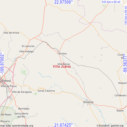
Villa Juárez GPS coordinates[2]
22° 19' 34.212" North, 100° 16' 0.804" West
| Map corner | latitude | longitude |
|---|---|---|
| Upper-left | 22.97506°, | -100.97002° |
| Center: | 22.32617°, | -100.26689° |
| Lower-right: | 21.67425°, | -99.56377° |
| Map W x H: | 144.6×144.6 km | = 89.9×89.9mi |
| max Lat: | 32.7° ⇑14.1% North |
| Villa Juárez: | 22.32617° |
| min Lat: | ⇓85.9% South 14.53588° |
| min Long | Villa Juárez | max Long |
| -117.105° | -100.26689° | -86.73105° |
| W 32.9%⇐ | ⇒67.1% E |
Elevation
Elevation of Villa Juárez is 1108 m = 3635 ft, and this is 145.7 m = 478 ft below average elevation for this country.
| Max E: |
3497 m = 11473 ft | 57.8% |
| Avg. | 1253.7 m = 4113 ft | |
| Villa Juárez | 1108 m = 3635 ft | |
Min E: |
-1 m = -3 ft | 42.2% |
See also: Mexico elevation on elevation.city.
Geographical zone
Villa Juárez is located in North Torrid zone (between Equator and Tropic of Cancer). Distance of this Northern Tropic circle is 123.5 km =76.7 mi to North.| Distance of | km | miles | from Villa Juárez |
|---|---|---|---|
| North Pole | 7524.6 | 4675.6 | to North |
| Arctic Circle | 4918.7 | 3056.3 | to North |
| Tropic Cancer | 123.5 | 76.7 | to North |
| Equator | 2482.4 | 1542.5 | to South |


Nearby cities:
15 places around Villa Juárez: (largest is in red/bold)
• Buenavista
32.8 km =20.4 mi,  22°
22°
• Cerritos
11.5 km =7.1 mi,  350°
350°
• Derramaderos
21 km =13 mi,  357°
357°
• El Quelital
25.9 km =16.1 mi, 16°
• Granjenal
21.7 km =13.5 mi,  70°
70°
• Joya de Luna
20 km =12.4 mi,  307°
307°
• La Concordia
32.9 km =20.4 mi,  275°
275°
• Ojo de Agua
22.2 km =13.8 mi,  53°
53°
• Palo Seco (El Gato)
8.3 km =5.2 mi, 68°
• Pastora
30.2 km =18.8 mi,  134°
134°
• Progreso
18 km =11.2 mi, 127°
• Puerta del Río
9.7 km =6 mi,  176°
176°
• San Bartolo
23 km =14.3 mi,  96°
96°
• San Nicolás Tolentino
30.6 km =19 mi,  253°
253°
• Santo Domingo
11.1 km =6.9 mi,  115°
115°
Sources, notices
• [Note1] Compared only with cities in Mexico existing in our database
• [Src1] Map data: © OpenStreetMap contributors (CC-BY-SA)
• [Src2] Other city data from geonames.org with taken over terms of usage.
• [Src3] Geographical zone / Annual Mean Temperature by Robert A. Rohde @ Wikipedia
