Puerta del Río geodata
Puerta del Río (San Luis Potosí) is a populated place; located in Mexico in America/Mexico_City (GMT-6) time zone. With population of 584 people, there are 14684 cities with bigger population in this country. Compared to other cities in Mexico, 85.4% of cities are located further ↓South; 67% of cities are located further →East and 57.6% of cities have higher elevation than Puerta del Río. Note1


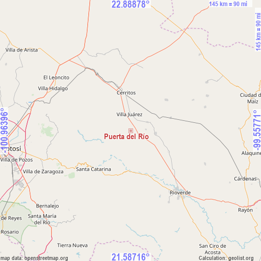
Puerta del Río GPS coordinates[2]
22° 14' 22.128" North, 100° 15' 38.988" West
| Map corner | latitude | longitude |
|---|---|---|
| Upper-left | 22.88878°, | -100.96396° |
| Center: | 22.23948°, | -100.26083° |
| Lower-right: | 21.58716°, | -99.55771° |
| Map W x H: | 144.7×144.7 km | = 89.9×89.9mi |
| max Lat: | 32.7° ⇑14.6% North |
| Puerta del Río: | 22.23948° |
| min Lat: | ⇓85.4% South 14.53588° |
| min Long | Puerta del Río | max Long |
| -117.105° | -100.26083° | -86.73105° |
| W 33%⇐ | ⇒67% E |
Elevation
Elevation of Puerta del Río is 1112 m = 3648 ft, and this is 141.7 m = 465 ft below average elevation for this country.
| Max E: |
3497 m = 11473 ft | 57.6% |
| Avg. | 1253.7 m = 4113 ft | |
| Puerta del Río | 1112 m = 3648 ft | |
Min E: |
-1 m = -3 ft | 42.4% |
See also: Mexico elevation on elevation.city.
Geographical zone
Puerta del Río is located in North Torrid zone (between Equator and Tropic of Cancer). Distance of this Northern Tropic circle is 133.1 km =82.7 mi to North.| Distance of | km | miles | from Puerta del Río |
|---|---|---|---|
| North Pole | 7534.3 | 4681.6 | to North |
| Arctic Circle | 4928.4 | 3062.4 | to North |
| Tropic Cancer | 133.1 | 82.7 | to North |
| Equator | 2472.8 | 1536.5 | to South |


Nearby cities:
15 places around Puerta del Río: (largest is in red/bold)
• Cerritos
21.1 km =13.1 mi,  353°
353°
• Granjenal
26.1 km =16.2 mi,  49°
49°
• Joya de Luna
27.3 km =17 mi,  322°
322°
• La Noria
28.9 km =18 mi,  149°
149°
• La Tapona
28.5 km =17.7 mi,  162°
162°
• Labor Vieja
28 km =17.4 mi, 154°
• Ojo de Agua
28.5 km =17.7 mi,  37°
37°
• Palo Seco (El Gato)
14.6 km =9.1 mi,  29°
29°
• Pastora
23.9 km =14.9 mi,  118°
118°
• Progreso
13.7 km =8.5 mi,  95°
95°
• San Bartolo
23.4 km =14.5 mi,  72°
72°
• San Nicolás Tolentino
30 km =18.6 mi,  272°
272°
• Santa Catarina
29.6 km =18.4 mi,  223°
223°
• Santo Domingo
10.6 km =6.6 mi,  62°
62°
• Villa Juárez
9.7 km =6 mi,  356°
356°
Sources, notices
• [Note1] Compared only with cities in Mexico existing in our database
• [Src1] Map data: © OpenStreetMap contributors (CC-BY-SA)
• [Src2] Other city data from geonames.org with taken over terms of usage.
• [Src3] Geographical zone / Annual Mean Temperature by Robert A. Rohde @ Wikipedia
