El Tepehuaje geodata
El Tepehuaje (Michoacán) is a populated place; located in Mexico in America/Mexico_City (GMT-6) time zone. With population of 796 people, there are 10956 cities with bigger population in this country. Compared to other cities in Mexico, 58.6% of cities are located further ↓South; 83.5% of cities are located further →East and 53.9% of cities have lower elevation than El Tepehuaje. Note1


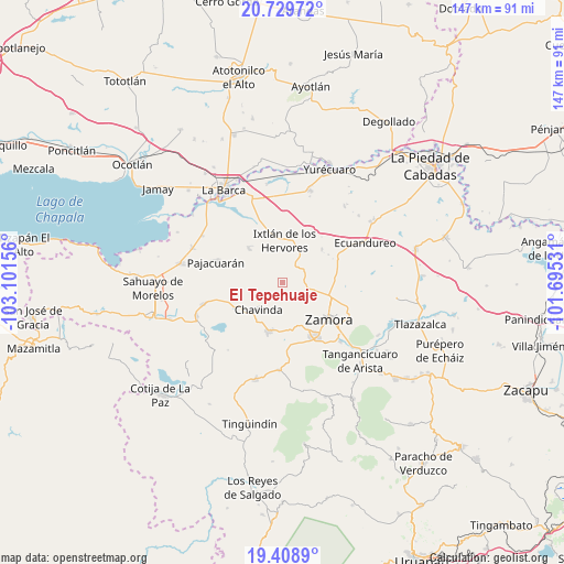
El Tepehuaje GPS coordinates[2]
20° 4' 14.52" North, 102° 23' 54.348" West
| Map corner | latitude | longitude |
|---|---|---|
| Upper-left | 20.72972°, | -103.10156° |
| Center: | 20.0707°, | -102.39843° |
| Lower-right: | 19.4089°, | -101.69531° |
| Map W x H: | 146.9×146.9 km | = 91.3×91.3mi |
| max Lat: | 32.7° ⇑41.4% North |
| El Tepehuaje: | 20.0707° |
| min Lat: | ⇓58.6% South 14.53588° |
| min Long | El Tepehuaje | max Long |
| -117.105° | -102.39843° | -86.73105° |
| W 16.5%⇐ | ⇒83.5% E |
Elevation
Elevation of El Tepehuaje is 1560 m = 5118 ft, and this is 306.3 m = 1005 ft above average elevation for this country.
| Max E: |
3497 m = 11473 ft | 46.1% |
| El Tepehuaje | 1560 m 5118 ft | |
| Avg. | 1253.7 m = 4113 ft | |
Min E: |
-1 m = -3 ft | 53.9% |
See also: Mexico elevation on elevation.city.
Geographical zone
El Tepehuaje is located in North Torrid zone (between Equator and Tropic of Cancer). Distance of this Northern Tropic circle is 374.3 km =232.6 mi to North.| Distance of | km | miles | from El Tepehuaje |
|---|---|---|---|
| North Pole | 7775.4 | 4831.4 | to North |
| Arctic Circle | 5169.5 | 3212.2 | to North |
| Tropic Cancer | 374.3 | 232.6 | to North |
| Equator | 2231.7 | 1386.7 | to South |


Nearby cities:
15 places around El Tepehuaje: (largest is in red/bold)
• Ario de Rayón
7.2 km =4.5 mi,  133°
133°
• Chavinda
9.6 km =6 mi,  221°
221°
• El Colongo
4.6 km =2.9 mi,  37°
37°
• El Limón
8.5 km =5.3 mi,  351°
351°
• El Llano
4.9 km =3 mi,  155°
155°
• El Salitre
11 km =6.8 mi,  13°
13°
• El Valenciano
10.6 km =6.6 mi,  324°
324°
• Ixtlán de los Hervores
10.9 km =6.8 mi,  1°
1°
• La Cuestita
9.7 km =6 mi,  266°
266°
• La Esperanza
2.1 km =1.3 mi, 218°
• La Estanzuela
6.2 km =3.9 mi,  29°
29°
• La Plaza del Limón
7.9 km =4.9 mi,  334°
334°
• La Sauceda
6.1 km =3.8 mi,  65°
65°
• Rincón del Mezquite
3.4 km =2.1 mi, 319°
• Tecomatán
11.4 km =7.1 mi,  295°
295°
Sources, notices
• [Note1] Compared only with cities in Mexico existing in our database
• [Src1] Map data: © OpenStreetMap contributors (CC-BY-SA)
• [Src2] Other city data from geonames.org with taken over terms of usage.
• [Src3] Geographical zone / Annual Mean Temperature by Robert A. Rohde @ Wikipedia
