Dolores geodata
Dolores (Chihuahua) is a populated place; located in Mexico in America/Chihuahua (GMT-6) time zone. With population of 517 people, there are 16282 cities with bigger population in this country. Compared to other cities in Mexico, 95.3% of cities are located further ↓South; 94.5% of cities are located further →East and 61.5% of cities have higher elevation than Dolores. Note1


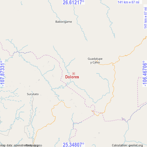
Dolores GPS coordinates[2]
25° 58' 54.552" North, 107° 10' 12.648" West
| Map corner | latitude | longitude |
|---|---|---|
| Upper-left | 26.61217°, | -107.87331° |
| Center: | 25.98182°, | -107.17018° |
| Lower-right: | 25.34807°, | -106.46706° |
| Map W x H: | 140.6×140.6 km | = 87.4×87.4mi |
| max Lat: | 32.7° ⇑4.7% North |
| Dolores: | 25.98182° |
| min Lat: | ⇓95.3% South 14.53588° |
| min Long | Dolores | max Long |
| -117.105° | -107.17018° | -86.73105° |
| W 5.5%⇐ | ⇒94.5% E |
Elevation
Elevation of Dolores is 908 m = 2979 ft, and this is 345.7 m = 1134 ft below average elevation for this country.
| Max E: |
3497 m = 11473 ft | 61.5% |
| Avg. | 1253.7 m = 4113 ft | |
| Dolores | 908 m = 2979 ft | |
Min E: |
-1 m = -3 ft | 38.5% |
See also: Mexico elevation on elevation.city.
Geographical zone
Dolores is located in North temperate zone (between Tropic of Cancer and the Arctic Circle). Distance of this Northern Tropic circle is 283 km =175.8 mi to South.| Distance of | km | miles | from Dolores |
|---|---|---|---|
| North Pole | 7118.2 | 4423 | to North |
| Arctic Circle | 4512.3 | 2803.8 | to North |
| Tropic Cancer | 283 | 175.8 | to South |
| Equator | 2888.9 | 1795.1 | to South |


Nearby cities:
15 places around Dolores: (largest is in red/bold)
• Baborigame
50.7 km =31.5 mi,  348°
348°
• Bacubirito
76.9 km =47.8 mi,  255°
255°
• Badiraguato
78.5 km =48.8 mi,  209°
209°
• El Durazno
61.8 km =38.4 mi,  156°
156°
• El Mezquite
81.4 km =50.6 mi,  239°
239°
• Guadalupe y Calvo
24 km =14.9 mi,  59°
59°
• Higuera de los Vega
86.8 km =53.9 mi,  245°
245°
• Las Yerbitas [Aserradero]
40.5 km =25.2 mi,  74°
74°
• Otatillos
68 km =42.3 mi,  194°
194°
• San Benito
76.9 km =47.8 mi,  230°
230°
• San José del Llano
27.3 km =17 mi,  217°
217°
• San Pedro de Chinatú (Ranchería San Pedro)
59.3 km =36.8 mi, 67°
• Surutato
43.7 km =27.2 mi, 243°
• Tamiapa
43.3 km =26.9 mi, 208°
• Turuachi
49.4 km =30.7 mi, 70°
Sources, notices
• [Note1] Compared only with cities in Mexico existing in our database
• [Src1] Map data: © OpenStreetMap contributors (CC-BY-SA)
• [Src2] Other city data from geonames.org with taken over terms of usage.
• [Src3] Geographical zone / Annual Mean Temperature by Robert A. Rohde @ Wikipedia
