Baborigame geodata
Baborigame (Chihuahua) is a populated place; located in Mexico in America/Chihuahua (GMT-6) time zone. With population of 3,294 people, there are 2758 cities with bigger population in this country. Compared to other cities in Mexico, 95.8% of cities are located further ↓South; 94.6% of cities are located further →East and 72.8% of cities have lower elevation than Baborigame. Note1


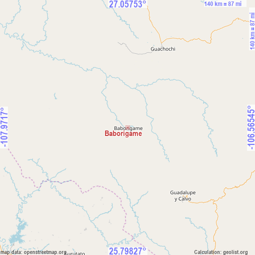
Baborigame GPS coordinates[2]
26° 25' 46.632" North, 107° 16' 6.852" West
| Map corner | latitude | longitude |
|---|---|---|
| Upper-left | 27.05753°, | -107.9717° |
| Center: | 26.42962°, | -107.26857° |
| Lower-right: | 25.79827°, | -106.56545° |
| Map W x H: | 140×140 km | = 87×87mi |
| max Lat: | 32.7° ⇑4.2% North |
| Baborigame: | 26.42962° |
| min Lat: | ⇓95.8% South 14.53588° |
| min Long | Baborigame | max Long |
| -117.105° | -107.26857° | -86.73105° |
| W 5.4%⇐ | ⇒94.6% E |
Elevation
Elevation of Baborigame is 1985 m = 6512 ft, and this is 731.3 m = 2399 ft above average elevation for this country.
| Max E: |
3497 m = 11473 ft | 27.2% |
| Baborigame | 1985 m 6512 ft | |
| Avg. | 1253.7 m = 4113 ft | |
Min E: |
-1 m = -3 ft | 72.8% |
See also: Mexico elevation on elevation.city.
Geographical zone
Baborigame is located in North temperate zone (between Tropic of Cancer and the Arctic Circle). Distance of this Northern Tropic circle is 332.8 km =206.8 mi to South.| Distance of | km | miles | from Baborigame |
|---|---|---|---|
| North Pole | 7068.4 | 4392.1 | to North |
| Arctic Circle | 4462.5 | 2772.9 | to North |
| Tropic Cancer | 332.8 | 206.8 | to South |
| Equator | 2938.7 | 1826 | to South |


Nearby cities:
15 places around Baborigame: (largest is in red/bold)
• Bacubirito
94.4 km =58.7 mi,  223°
223°
• Batopilas
81.5 km =50.6 mi,  324°
324°
• Dolores
50.7 km =31.5 mi,  168°
168°
• Ejido El Vergel
88.3 km =54.9 mi,  86°
86°
• Guachochi
47.5 km =29.5 mi,  23°
23°
• Guadalupe y Calvo
48.4 km =30.1 mi,  140°
140°
• Las Yerbitas [Aserradero]
62.3 km =38.7 mi,  128°
128°
• Morelos
48.8 km =30.3 mi,  303°
303°
• Polanco (Ranchería Mineral Polanco)
57.9 km =36 mi, 320°
• San José del Llano
71.7 km =44.6 mi,  185°
185°
• San Pedro de Chinatú (Ranchería San Pedro)
70 km =43.5 mi,  112°
112°
• Surutato
75.2 km =46.7 mi,  202°
202°
• Tamiapa
88.6 km =55.1 mi, 186°
• Turuachi
65.3 km =40.6 mi,  120°
120°
• Yoquivo
71.3 km =44.3 mi,  338°
338°
Sources, notices
• [Note1] Compared only with cities in Mexico existing in our database
• [Src1] Map data: © OpenStreetMap contributors (CC-BY-SA)
• [Src2] Other city data from geonames.org with taken over terms of usage.
• [Src3] Geographical zone / Annual Mean Temperature by Robert A. Rohde @ Wikipedia
