Guadalupe y Calvo geodata
Guadalupe y Calvo (Chihuahua) is a seat of a second-order administrative division; located in Mexico in America/Chihuahua (GMT-6) time zone. With population of 5,816 people, there are 1596 cities with bigger population in this country. Compared to other cities in Mexico, 95.5% of cities are located further ↓South; 94.4% of cities are located further →East and 87.2% of cities have lower elevation than Guadalupe y Calvo. Note1


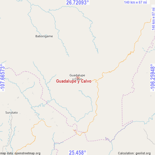
Guadalupe y Calvo GPS coordinates[2]
26° 5' 28.212" North, 106° 57' 45.36" West
| Map corner | latitude | longitude |
|---|---|---|
| Upper-left | 26.72093°, | -107.66573° |
| Center: | 26.09117°, | -106.9626° |
| Lower-right: | 25.458°, | -106.25948° |
| Map W x H: | 140.4×140.4 km | = 87.2×87.2mi |
| max Lat: | 32.7° ⇑4.5% North |
| Guadalupe y Calvo: | 26.09117° |
| min Lat: | ⇓95.5% South 14.53588° |
| min Long | Guadalupe y Cal | max Long |
| -117.105° | -106.9626° | -86.73105° |
| W 5.6%⇐ | ⇒94.4% E |
Elevation
Elevation of Guadalupe y Calvo is 2315 m = 7595 ft, and this is 1061.3 m = 3482 ft above average elevation for this country.
| Max E: |
3497 m = 11473 ft | 12.8% |
| Guadalupe y Calvo | 2315 m 7595 ft | |
| Avg. | 1253.7 m = 4113 ft | |
Min E: |
-1 m = -3 ft | 87.2% |
See also: Mexico elevation on elevation.city.
Geographical zone
Guadalupe y Calvo is located in North temperate zone (between Tropic of Cancer and the Arctic Circle). Distance of this Northern Tropic circle is 295.1 km =183.4 mi to South.| Distance of | km | miles | from Guadalupe y Calvo |
|---|---|---|---|
| North Pole | 7106 | 4415.5 | to North |
| Arctic Circle | 4500.1 | 2796.2 | to North |
| Tropic Cancer | 295.1 | 183.4 | to South |
| Equator | 2901.1 | 1802.7 | to South |


Nearby cities:
15 places around Guadalupe y Calvo: (largest is in red/bold)
• Arroyo de Lajas
68.6 km =42.6 mi,  103°
103°
• Baborigame
48.4 km =30.1 mi,  320°
320°
• Badiraguato
99.9 km =62.1 mi,  216°
216°
• Dolores
24 km =14.9 mi,  239°
239°
• Ejido El Vergel
71.6 km =44.5 mi,  53°
53°
• El Durazno
69.1 km =42.9 mi,  177°
177°
• Guachochi
81.8 km =50.8 mi,  352°
352°
• Las Yerbitas [Aserradero]
18.3 km =11.4 mi,  93°
93°
• Morelos
96.1 km =59.7 mi,  312°
312°
• Otatillos
86.6 km =53.8 mi,  205°
205°
• San José del Llano
50.4 km =31.3 mi,  227°
227°
• San Pedro de Chinatú (Ranchería San Pedro)
35.7 km =22.2 mi,  72°
72°
• Surutato
67.7 km =42.1 mi, 242°
• Tamiapa
65.1 km =40.5 mi, 219°
• Turuachi
26.2 km =16.3 mi,  80°
80°
Sources, notices
• [Note1] Compared only with cities in Mexico existing in our database
• [Src1] Map data: © OpenStreetMap contributors (CC-BY-SA)
• [Src2] Other city data from geonames.org with taken over terms of usage.
• [Src3] Geographical zone / Annual Mean Temperature by Robert A. Rohde @ Wikipedia
