La Laguna geodata
La Laguna (Guanajuato) is a populated place; located in Mexico in America/Mexico_City (GMT-6) time zone. With population of 516 people, there are 16314 cities with bigger population in this country. Compared to other cities in Mexico, 78.1% of cities are located further ↓South; 69.1% of cities are located further →East and 75.6% of cities have lower elevation than La Laguna. Note1


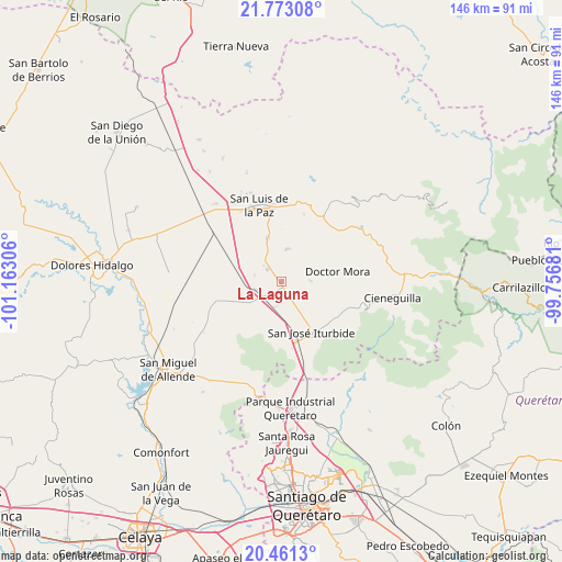
La Laguna GPS coordinates[2]
21° 7' 7.104" North, 100° 27' 35.748" West
| Map corner | latitude | longitude |
|---|---|---|
| Upper-left | 21.77308°, | -101.16306° |
| Center: | 21.11864°, | -100.45993° |
| Lower-right: | 20.4613°, | -99.75681° |
| Map W x H: | 145.9×145.9 km | = 90.7×90.7mi |
| max Lat: | 32.7° ⇑21.9% North |
| La Laguna: | 21.11864° |
| min Lat: | ⇓78.1% South 14.53588° |
| min Long | La Laguna | max Long |
| -117.105° | -100.45993° | -86.73105° |
| W 30.9%⇐ | ⇒69.1% E |
Elevation
Elevation of La Laguna is 2041 m = 6696 ft, and this is 787.3 m = 2583 ft above average elevation for this country.
| Max E: |
3497 m = 11473 ft | 24.4% |
| La Laguna | 2041 m 6696 ft | |
| Avg. | 1253.7 m = 4113 ft | |
Min E: |
-1 m = -3 ft | 75.6% |
See also: Mexico elevation on elevation.city.
Geographical zone
La Laguna is located in North Torrid zone (between Equator and Tropic of Cancer). Distance of this Northern Tropic circle is 257.7 km =160.1 mi to North.| Distance of | km | miles | from La Laguna |
|---|---|---|---|
| North Pole | 7658.9 | 4759 | to North |
| Arctic Circle | 5053 | 3139.8 | to North |
| Tropic Cancer | 257.7 | 160.1 | to North |
| Equator | 2348.2 | 1459.1 | to South |


Nearby cities:
15 places around La Laguna: (largest is in red/bold)
• Derramadero Segundo (Infiernillo)
6.1 km =3.8 mi,  247°
247°
• El Varal (La Merced)
8.5 km =5.3 mi,  11°
11°
• Galomo
7 km =4.3 mi,  158°
158°
• La Luz de la Esquina
4.6 km =2.9 mi,  305°
305°
• La Noria
7.9 km =4.9 mi,  89°
89°
• La Reforma
10.2 km =6.3 mi,  135°
135°
• Las Adjuntas
8 km =5 mi, 143°
• Morisquilla
12 km =7.5 mi,  104°
104°
• Pueblo Nuevo
5.9 km =3.7 mi,  111°
111°
• San Antonio Primero
7.6 km =4.7 mi, 249°
• San Ernesto
9.1 km =5.7 mi,  285°
285°
• San Rafael
11 km =6.8 mi,  81°
81°
• San Sebastián de Salitre
2.8 km =1.7 mi,  230°
230°
• Tulillos de Abajo
4.4 km =2.7 mi,  214°
214°
• Tulillos de Arriba
5.4 km =3.4 mi,  190°
190°
Sources, notices
• [Note1] Compared only with cities in Mexico existing in our database
• [Src1] Map data: © OpenStreetMap contributors (CC-BY-SA)
• [Src2] Other city data from geonames.org with taken over terms of usage.
• [Src3] Geographical zone / Annual Mean Temperature by Robert A. Rohde @ Wikipedia
