El Paraíso geodata
El Paraíso (Veracruz) is a populated place; located in Mexico in America/Mexico_City (GMT-6) time zone. With population of 688 people, there are 12631 cities with bigger population in this country. Compared to other cities in Mexico, 78.3% of cities are located further ↑North; 83.2% of cities are located further ←West and 81.5% of cities have higher elevation than El Paraíso. Note1


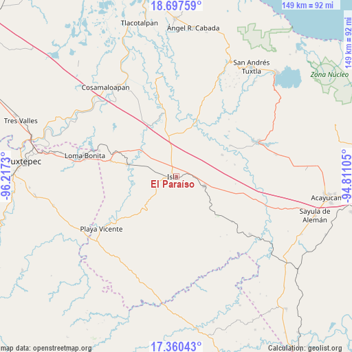
El Paraíso GPS coordinates[2]
18° 1' 49.008" North, 95° 30' 51.012" West
| Map corner | latitude | longitude |
|---|---|---|
| Upper-left | 18.69759°, | -96.2173° |
| Center: | 18.03028°, | -95.51417° |
| Lower-right: | 17.36043°, | -94.81105° |
| Map W x H: | 148.7×148.7 km | = 92.4×92.4mi |
| max Lat: | 32.7° ⇑78.3% North |
| El Paraíso: | 18.03028° |
| min Lat: | ⇓21.7% South 14.53588° |
| min Long | El Paraíso | max Long |
| -117.105° | -95.51417° | -86.73105° |
| W 83.2%⇐ | ⇒16.8% E |
Elevation
Elevation of El Paraíso is 76 m = 249 ft, and this is 1177.7 m = 3864 ft below average elevation for this country.
| Max E: |
3497 m = 11473 ft | 81.5% |
| Avg. | 1253.7 m = 4113 ft | |
| El Paraíso | 76 m = 249 ft | |
Min E: |
-1 m = -3 ft | 18.5% |
See also: Mexico elevation on elevation.city.
Geographical zone
El Paraíso is located in North Torrid zone (between Equator and Tropic of Cancer). Distance of this Northern Tropic circle is 601.1 km =373.5 mi to North.| Distance of | km | miles | from El Paraíso |
|---|---|---|---|
| North Pole | 8002.3 | 4972.4 | to North |
| Arctic Circle | 5396.4 | 3353.2 | to North |
| Tropic Cancer | 601.1 | 373.5 | to North |
| Equator | 2004.8 | 1245.7 | to South |


Nearby cities:
15 places around El Paraíso: (largest is in red/bold)
• Curazao
19.9 km =12.4 mi,  293°
293°
• El Maguey
20.2 km =12.6 mi,  283°
283°
• El Marcial
18.7 km =11.6 mi,  253°
253°
• El Tesoro
21.9 km =13.6 mi,  23°
23°
• Isla
1.6 km =1 mi,  260°
260°
• Juan Rodríguez Clara
12.7 km =7.9 mi,  109°
109°
• La Unión
9.8 km =6.1 mi,  31°
31°
• Loma Alta
13.9 km =8.6 mi, 245°
• Mazoco
11.2 km =7 mi, 290°
• Nopalapan
21.4 km =13.3 mi,  64°
64°
• Nuevo Potrero
12.9 km =8 mi,  309°
309°
• San Jerónimo
20.4 km =12.7 mi, 255°
• Tesechoacan
19.3 km =12 mi, 308°
• Totoloche
13.7 km =8.5 mi,  187°
187°
• Villa Azueta
21.5 km =13.4 mi, 283°
Sources, notices
• [Note1] Compared only with cities in Mexico existing in our database
• [Src1] Map data: © OpenStreetMap contributors (CC-BY-SA)
• [Src2] Other city data from geonames.org with taken over terms of usage.
• [Src3] Geographical zone / Annual Mean Temperature by Robert A. Rohde @ Wikipedia
