Tepetzintla de Galeana geodata
Tepetzintla de Galeana (Puebla) is a populated place; located in Mexico in America/Mexico_City (GMT-6) time zone. With population of 738 people, there are 11838 cities with bigger population in this country. Compared to other cities in Mexico, 63.1% of cities are located further ↓South; 63.3% of cities are located further ←West and 52.3% of cities have lower elevation than Tepetzintla de Galeana. Note1


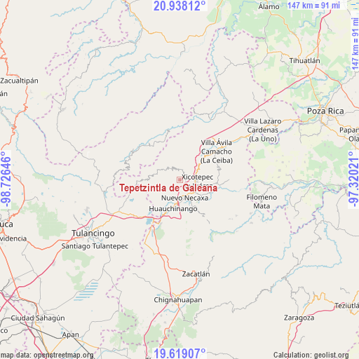
Tepetzintla de Galeana GPS coordinates[2]
20° 16' 48" North, 98° 1' 23.988" West
| Map corner | latitude | longitude |
|---|---|---|
| Upper-left | 20.93812°, | -98.72646° |
| Center: | 20.28°, | -98.02333° |
| Lower-right: | 19.61907°, | -97.32021° |
| Map W x H: | 146.7×146.7 km | = 91.2×91.2mi |
| max Lat: | 32.7° ⇑36.9% North |
| Tepetzintla de Galeana: | 20.28° |
| min Lat: | ⇓63.1% South 14.53588° |
| min Long | Tepetzintla de | max Long |
| -117.105° | -98.02333° | -86.73105° |
| W 63.3%⇐ | ⇒36.7% E |
Elevation
Elevation of Tepetzintla de Galeana is 1529 m = 5016 ft, and this is 275.3 m = 903 ft above average elevation for this country.
| Max E: |
3497 m = 11473 ft | 47.7% |
| Tepetzintla de Galeana | 1529 m 5016 ft | |
| Avg. | 1253.7 m = 4113 ft | |
Min E: |
-1 m = -3 ft | 52.3% |
See also: Mexico elevation on elevation.city.
Geographical zone
Tepetzintla de Galeana is located in North Torrid zone (between Equator and Tropic of Cancer). Distance of this Northern Tropic circle is 351 km =218.1 mi to North.| Distance of | km | miles | from Tepetzintla de Galeana |
|---|---|---|---|
| North Pole | 7752.1 | 4816.9 | to North |
| Arctic Circle | 5146.2 | 3197.7 | to North |
| Tropic Cancer | 351 | 218.1 | to North |
| Equator | 2254.9 | 1401.1 | to South |


Nearby cities:
15 places around Tepetzintla de Galeana: (largest is in red/bold)
• Copila
6.3 km =3.9 mi,  262°
262°
• Cuautepec
6.8 km =4.2 mi,  343°
343°
• Cuaxicala
4.6 km =2.9 mi,  184°
184°
• Cueyatla
6.4 km =4 mi,  281°
281°
• Duraznotla
5.2 km =3.2 mi,  112°
112°
• Itzatlán
7.3 km =4.5 mi,  33°
33°
• Necaxa
7.6 km =4.7 mi,  170°
170°
• Necaxaltépetl
5.7 km =3.5 mi,  150°
150°
• Nuevo Necaxa
7.9 km =4.9 mi, 167°
• Ozomatlán
1.5 km =0.9 mi,  271°
271°
• San Isidro
7.3 km =4.5 mi,  117°
117°
• Santa María
5.1 km =3.2 mi,  320°
320°
• Tlacuilotepec
6.9 km =4.3 mi, 317°
• Tlapehuala
3.7 km =2.3 mi,  350°
350°
• Xicotepec de Juárez
6.5 km =4 mi,  93°
93°
Sources, notices
• [Note1] Compared only with cities in Mexico existing in our database
• [Src1] Map data: © OpenStreetMap contributors (CC-BY-SA)
• [Src2] Other city data from geonames.org with taken over terms of usage.
• [Src3] Geographical zone / Annual Mean Temperature by Robert A. Rohde @ Wikipedia
