Chichihualco geodata
Chichihualco (Guerrero) is a seat of a second-order administrative division; located in Mexico in America/Mexico_City (GMT-6) time zone. With population of 10,690 people, there are 891 cities with bigger population in this country. Compared to other cities in Mexico, 81.7% of cities are located further ↑North; 59.9% of cities are located further →East and 56.3% of cities have higher elevation than Chichihualco. Note1


Chichihualco GPS coordinates[2]
17° 39' 32.472" North, 99° 40' 34.464" West
| Map corner | latitude | longitude |
|---|---|---|
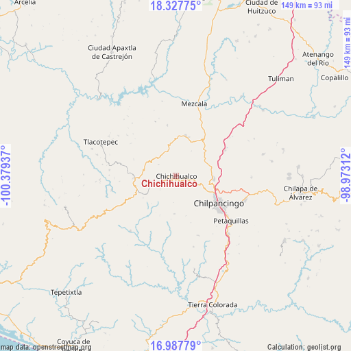
| Upper-left | 18.32775°, | -100.37937° |
| Center: | 17.65902°, | -99.67624° |
| Lower-right: | 16.98779°, | -98.97312° |
| Map W x H: | 149×149 km | = 92.6×92.6mi |
| max Lat: | 32.7° ⇑81.7% North |
| Chichihualco: | 17.65902° |
| min Lat: | ⇓18.3% South 14.53588° |
| min Long | Chichihualco | max Long |
| -117.105° | -99.67624° | -86.73105° |
| W 40.1%⇐ | ⇒59.9% E |
Elevation
Elevation of Chichihualco is 1148 m = 3766 ft, and this is 105.7 m = 347 ft below average elevation for this country.
| Max E: |
3497 m = 11473 ft | 56.3% |
| Avg. | 1253.7 m = 4113 ft | |
| Chichihualco | 1148 m = 3766 ft | |
Min E: |
-1 m = -3 ft | 43.7% |
See also: Mexico elevation on elevation.city.
Geographical zone
Chichihualco is located in North Torrid zone (between Equator and Tropic of Cancer). Distance of this Northern Tropic circle is 642.4 km =399.2 mi to North.| Distance of | km | miles | from Chichihualco |
|---|---|---|---|
| North Pole | 8043.6 | 4998.1 | to North |
| Arctic Circle | 5437.7 | 3378.8 | to North |
| Tropic Cancer | 642.4 | 399.2 | to North |
| Equator | 1963.5 | 1220.1 | to South |


Nearby cities:
15 places around Chichihualco: (largest is in red/bold)
• Amojileca
15.1 km =9.4 mi,  131°
131°
• Atlixtac
5.1 km =3.2 mi,  108°
108°
• Campo de Aviación
15.2 km =9.4 mi,  269°
269°
• Carrizal de Bravo
17.6 km =10.9 mi,  255°
255°
• Carrizalillo
21.7 km =13.5 mi,  349°
349°
• Chilpancingo
21.7 km =13.5 mi,  123°
123°
• El Balzamar
16.9 km =10.5 mi,  236°
236°
• El Naranjo
8.8 km =5.5 mi,  303°
303°
• El Palmar
7.8 km =4.8 mi,  97°
97°
• Iyotla
8.6 km =5.3 mi, 241°
• Puerto General Nicolás Bravo (Filo de Caballos)
17.8 km =11.1 mi, 266°
• San Vicente
16.1 km =10 mi,  182°
182°
• Tepozonalco
9.2 km =5.7 mi,  227°
227°
• Xochipala
17.4 km =10.8 mi,  12°
12°
• Zumpango del Río
15.8 km =9.8 mi,  91°
91°
Sources, notices
• [Note1] Compared only with cities in Mexico existing in our database
• [Src1] Map data: © OpenStreetMap contributors (CC-BY-SA)
• [Src2] Other city data from geonames.org with taken over terms of usage.
• [Src3] Geographical zone / Annual Mean Temperature by Robert A. Rohde @ Wikipedia
