Ozomatlán geodata
Ozomatlán (Puebla) is a populated place; located in Mexico in America/Mexico_City (GMT-6) time zone. With population of 723 people, there are 12083 cities with bigger population in this country. Compared to other cities in Mexico, 63.1% of cities are located further ↓South; 63.2% of cities are located further ←West and 53.3% of cities have lower elevation than Ozomatlán. Note1


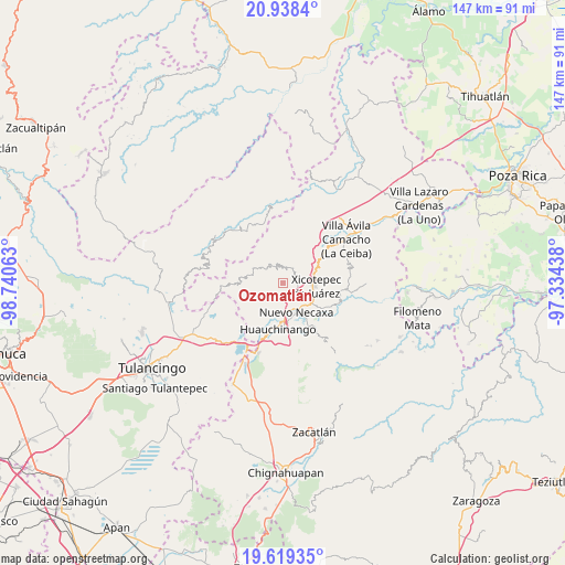
Ozomatlán GPS coordinates[2]
20° 16' 49.008" North, 98° 2' 15" West
| Map corner | latitude | longitude |
|---|---|---|
| Upper-left | 20.9384°, | -98.74063° |
| Center: | 20.28028°, | -98.0375° |
| Lower-right: | 19.61935°, | -97.33438° |
| Map W x H: | 146.7×146.7 km | = 91.2×91.2mi |
| max Lat: | 32.7° ⇑36.9% North |
| Ozomatlán: | 20.28028° |
| min Lat: | ⇓63.1% South 14.53588° |
| min Long | Ozomatlán | max Long |
| -117.105° | -98.0375° | -86.73105° |
| W 63.2%⇐ | ⇒36.8% E |
Elevation
Elevation of Ozomatlán is 1547 m = 5075 ft, and this is 293.3 m = 962 ft above average elevation for this country.
| Max E: |
3497 m = 11473 ft | 46.7% |
| Ozomatlán | 1547 m 5075 ft | |
| Avg. | 1253.7 m = 4113 ft | |
Min E: |
-1 m = -3 ft | 53.3% |
See also: Mexico elevation on elevation.city.
Geographical zone
Ozomatlán is located in North Torrid zone (between Equator and Tropic of Cancer). Distance of this Northern Tropic circle is 351 km =218.1 mi to North.| Distance of | km | miles | from Ozomatlán |
|---|---|---|---|
| North Pole | 7752.1 | 4816.9 | to North |
| Arctic Circle | 5146.2 | 3197.7 | to North |
| Tropic Cancer | 351 | 218.1 | to North |
| Equator | 2255 | 1401.2 | to South |


Nearby cities:
15 places around Ozomatlán: (largest is in red/bold)
• Acalapa
6.9 km =4.3 mi,  303°
303°
• Copila
4.8 km =3 mi,  260°
260°
• Cuauneutla de la Paz
7.8 km =4.8 mi, 299°
• Cuautepec
6.5 km =4 mi,  355°
355°
• Cuaxicala
4.7 km =2.9 mi,  166°
166°
• Cueyatla
4.9 km =3 mi,  285°
285°
• Duraznotla
6.6 km =4.1 mi,  107°
107°
• Icxotitla
7.8 km =4.8 mi,  237°
237°
• Necaxa
8 km =5 mi,  160°
160°
• Necaxaltépetl
6.6 km =4.1 mi,  139°
139°
• Santa María
4.3 km =2.7 mi,  336°
336°
• Tepetzintla de Galeana
1.5 km =0.9 mi,  91°
91°
• Tlacuilotepec
6 km =3.7 mi,  327°
327°
• Tlapehuala
3.7 km =2.3 mi,  13°
13°
• Xicotepec de Juárez
8 km =5 mi, 93°
Sources, notices
• [Note1] Compared only with cities in Mexico existing in our database
• [Src1] Map data: © OpenStreetMap contributors (CC-BY-SA)
• [Src2] Other city data from geonames.org with taken over terms of usage.
• [Src3] Geographical zone / Annual Mean Temperature by Robert A. Rohde @ Wikipedia
