Santa Cruz Tutiahua geodata
Santa Cruz Tutiahua (Oaxaca) is a populated place; located in Mexico in America/Mexico_City (GMT-6) time zone. With population of 644 people, there are 13427 cities with bigger population in this country. Compared to other cities in Mexico, 92.1% of cities are located further ↑North; 64.7% of cities are located further ←West and 63.9% of cities have higher elevation than Santa Cruz Tutiahua. Note1


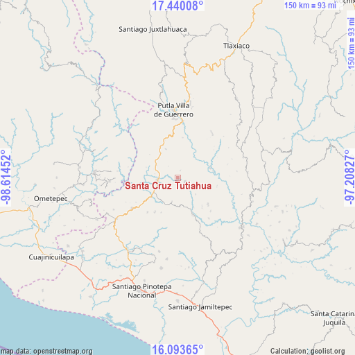
Santa Cruz Tutiahua GPS coordinates[2]
16° 46' 5.016" North, 97° 54' 41.004" West
| Map corner | latitude | longitude |
|---|---|---|
| Upper-left | 17.44008°, | -98.61452° |
| Center: | 16.76806°, | -97.91139° |
| Lower-right: | 16.09365°, | -97.20827° |
| Map W x H: | 149.7×149.7 km | = 93×93mi |
| max Lat: | 32.7° ⇑92.1% North |
| Santa Cruz Tutiahua: | 16.76806° |
| min Lat: | ⇓7.9% South 14.53588° |
| min Long | Santa Cruz Tuti | max Long |
| -117.105° | -97.91139° | -86.73105° |
| W 64.7%⇐ | ⇒35.3% E |
Elevation
Elevation of Santa Cruz Tutiahua is 759 m = 2490 ft, and this is 494.7 m = 1623 ft below average elevation for this country.
| Max E: |
3497 m = 11473 ft | 63.9% |
| Avg. | 1253.7 m = 4113 ft | |
| Santa Cruz Tutiahua | 759 m = 2490 ft | |
Min E: |
-1 m = -3 ft | 36.1% |
See also: Mexico elevation on elevation.city.
Geographical zone
Santa Cruz Tutiahua is located in North Torrid zone (between Equator and Tropic of Cancer). Distance of this Northern Tropic circle is 741.5 km =460.7 mi to North.| Distance of | km | miles | from Santa Cruz Tutiahua |
|---|---|---|---|
| North Pole | 8142.6 | 5059.6 | to North |
| Arctic Circle | 5536.7 | 3440.3 | to North |
| Tropic Cancer | 741.5 | 460.7 | to North |
| Equator | 1864.4 | 1158.5 | to South |


Nearby cities:
15 places around Santa Cruz Tutiahua: (largest is in red/bold)
• Aquiles Serdán
11.8 km =7.3 mi,  317°
317°
• Asunción Atoyaquillo
14.3 km =8.9 mi,  73°
73°
• Concepción las Mesas
13.5 km =8.4 mi,  337°
337°
• El Rosario
12.7 km =7.9 mi,  325°
325°
• El Tapanco
10.3 km =6.4 mi,  300°
300°
• Guadalupe Nuevo Centro
3.3 km =2.1 mi,  17°
17°
• La Guadalupe
20.4 km =12.7 mi,  239°
239°
• La Reforma
17.5 km =10.9 mi,  156°
156°
• San Juan Cabeza del Río
3.5 km =2.2 mi,  118°
118°
• San Miguel Reyes
17.2 km =10.7 mi,  6°
6°
• San Vicente Piñas
16 km =9.9 mi,  276°
276°
• Santa María Ipalapa
19.2 km =11.9 mi,  221°
221°
• Santa María Zacatepec
8.4 km =5.2 mi,  266°
266°
• Zaragoza
16.7 km =10.4 mi,  131°
131°
• Zocoteaca de León
17.4 km =10.8 mi,  213°
213°
Sources, notices
• [Note1] Compared only with cities in Mexico existing in our database
• [Src1] Map data: © OpenStreetMap contributors (CC-BY-SA)
• [Src2] Other city data from geonames.org with taken over terms of usage.
• [Src3] Geographical zone / Annual Mean Temperature by Robert A. Rohde @ Wikipedia
