La Reforma geodata
La Reforma (Oaxaca) is a populated place; located in Mexico in America/Mexico_City (GMT-6) time zone. With population of 1,362 people, there are 6375 cities with bigger population in this country. Compared to other cities in Mexico, 93.4% of cities are located further ↑North; 65.5% of cities are located further ←West and 62.6% of cities have higher elevation than La Reforma. Note1


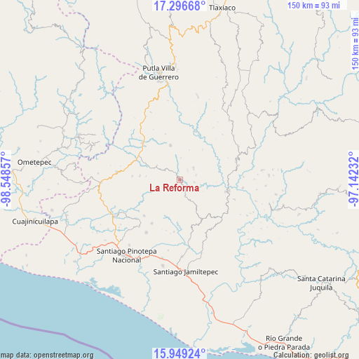
La Reforma GPS coordinates[2]
16° 37' 26.904" North, 97° 50' 43.584" West
| Map corner | latitude | longitude |
|---|---|---|
| Upper-left | 17.29668°, | -98.54857° |
| Center: | 16.62414°, | -97.84544° |
| Lower-right: | 15.94924°, | -97.14232° |
| Map W x H: | 149.8×149.8 km | = 93.1×93.1mi |
| max Lat: | 32.7° ⇑93.4% North |
| La Reforma: | 16.62414° |
| min Lat: | ⇓6.6% South 14.53588° |
| min Long | La Reforma | max Long |
| -117.105° | -97.84544° | -86.73105° |
| W 65.5%⇐ | ⇒34.5% E |
Elevation
Elevation of La Reforma is 845 m = 2772 ft, and this is 408.7 m = 1341 ft below average elevation for this country.
| Max E: |
3497 m = 11473 ft | 62.6% |
| Avg. | 1253.7 m = 4113 ft | |
| La Reforma | 845 m = 2772 ft | |
Min E: |
-1 m = -3 ft | 37.4% |
See also: Mexico elevation on elevation.city.
Geographical zone
La Reforma is located in North Torrid zone (between Equator and Tropic of Cancer). Distance of this Northern Tropic circle is 757.5 km =470.7 mi to North.| Distance of | km | miles | from La Reforma |
|---|---|---|---|
| North Pole | 8158.6 | 5069.5 | to North |
| Arctic Circle | 5552.7 | 3450.3 | to North |
| Tropic Cancer | 757.5 | 470.7 | to North |
| Equator | 1848.4 | 1148.5 | to South |


Nearby cities:
15 places around La Reforma: (largest is in red/bold)
• El Carasol
14.1 km =8.8 mi,  150°
150°
• El Frutillo
16.3 km =10.1 mi, 152°
• La Humedad
19.6 km =12.2 mi,  103°
103°
• La Muralla
14.7 km =9.1 mi,  178°
178°
• Llano Verde
19.5 km =12.1 mi,  115°
115°
• Nuevo Progreso
12.5 km =7.8 mi,  204°
204°
• San Cristóbal
15.7 km =9.8 mi,  187°
187°
• San Juan Cabeza del Río
14.8 km =9.2 mi,  344°
344°
• Santa Cruz Tutiahua
17.5 km =10.9 mi, 336°
• Santa María Ipalapa
19.9 km =12.4 mi,  274°
274°
• Santa María Nutío
16.6 km =10.3 mi, 202°
• Siniyuvi
18.6 km =11.6 mi,  207°
207°
• Villa Nueva
7.3 km =4.5 mi,  161°
161°
• Zaragoza
7.5 km =4.7 mi,  47°
47°
• Zocoteaca de León
16.8 km =10.4 mi,  275°
275°
Sources, notices
• [Note1] Compared only with cities in Mexico existing in our database
• [Src1] Map data: © OpenStreetMap contributors (CC-BY-SA)
• [Src2] Other city data from geonames.org with taken over terms of usage.
• [Src3] Geographical zone / Annual Mean Temperature by Robert A. Rohde @ Wikipedia
