Axaxacualco geodata
Axaxacualco (Guerrero) is a populated place; located in Mexico in America/Mexico_City (GMT-6) time zone. With population of 1,331 people, there are 6524 cities with bigger population in this country. Compared to other cities in Mexico, 80.5% of cities are located further ↑North; 56.4% of cities are located further →East and 50.6% of cities have lower elevation than Axaxacualco. Note1


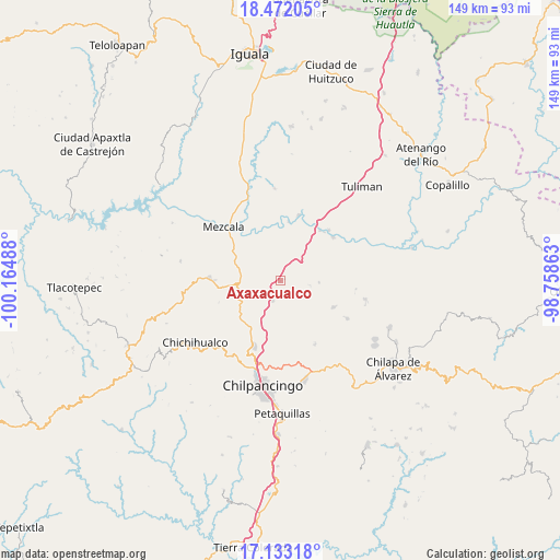
Axaxacualco GPS coordinates[2]
17° 48' 13.932" North, 99° 27' 42.3" West
| Map corner | latitude | longitude |
|---|---|---|
| Upper-left | 18.47205°, | -100.16488° |
| Center: | 17.80387°, | -99.46175° |
| Lower-right: | 17.13318°, | -98.75863° |
| Map W x H: | 148.9×148.9 km | = 92.5×92.5mi |
| max Lat: | 32.7° ⇑80.5% North |
| Axaxacualco: | 17.80387° |
| min Lat: | ⇓19.5% South 14.53588° |
| min Long | Axaxacualco | max Long |
| -117.105° | -99.46175° | -86.73105° |
| W 43.6%⇐ | ⇒56.4% E |
Elevation
Elevation of Axaxacualco is 1467 m = 4813 ft, and this is 213.3 m = 700 ft above average elevation for this country.
| Max E: |
3497 m = 11473 ft | 49.4% |
| Axaxacualco | 1467 m 4813 ft | |
| Avg. | 1253.7 m = 4113 ft | |
Min E: |
-1 m = -3 ft | 50.6% |
See also: Mexico elevation on elevation.city.
Geographical zone
Axaxacualco is located in North Torrid zone (between Equator and Tropic of Cancer). Distance of this Northern Tropic circle is 626.3 km =389.2 mi to North.| Distance of | km | miles | from Axaxacualco |
|---|---|---|---|
| North Pole | 8027.5 | 4988.1 | to North |
| Arctic Circle | 5421.6 | 3368.8 | to North |
| Tropic Cancer | 626.3 | 389.2 | to North |
| Equator | 1979.6 | 1230.1 | to South |


Nearby cities:
15 places around Axaxacualco: (largest is in red/bold)
• Ameyaltepec
18.7 km =11.6 mi,  344°
344°
• Apango
15.7 km =9.8 mi,  116°
116°
• Huitziltepec
5.6 km =3.5 mi,  199°
199°
• San Agustín Oapan
16.7 km =10.4 mi,  8°
8°
• San Agustín Ostotipan
17.6 km =10.9 mi,  42°
42°
• San Francisco Ozomatlán
18.7 km =11.6 mi, 43°
• San Juan Tetelcingo
14.4 km =8.9 mi, 335°
• San Juan Totolcintla
18.3 km =11.4 mi,  51°
51°
• San Marcos Oacatzingo
14.7 km =9.1 mi,  351°
351°
• San Miguel Tecuiciapan
18.3 km =11.4 mi,  15°
15°
• Tlamamacan
14.9 km =9.3 mi,  332°
332°
• Tlanipatla
1.2 km =0.7 mi,  66°
66°
• Tula del Río
17.1 km =10.6 mi, 38°
• Xochipala
18.9 km =11.7 mi,  272°
272°
• Zumpango del Río
18 km =11.2 mi, 202°
Sources, notices
• [Note1] Compared only with cities in Mexico existing in our database
• [Src1] Map data: © OpenStreetMap contributors (CC-BY-SA)
• [Src2] Other city data from geonames.org with taken over terms of usage.
• [Src3] Geographical zone / Annual Mean Temperature by Robert A. Rohde @ Wikipedia
