Koné geodata
Koné (North Province) is a seat of a first-order administrative division; located in New Caledonia in Pacific/Noumea (GMT+11) time zone. With population of 4,572 people, there are 8 cities with bigger population in this country. Compared to other cities in New Caledonia, 60% of cities are located further ↓South; 76.7% of cities are located further →East and 56.7% of cities have lower elevation than Koné. Note1


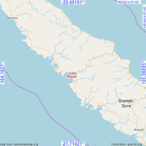
Koné GPS coordinates[2]
21° 3' 34.236" South, 164° 51' 56.952" East
| Map corner | latitude | longitude |
|---|---|---|
| Upper-left | -20.40191°, | 164.1627° |
| Center: | -21.05951°, | 164.86582° |
| Lower-right: | -21.71421°, | 165.56895° |
| Map W x H: | 145.9×145.9 km | = 90.7×90.7mi |
| max Lat: | -19.71161° ⇑40% North |
| Koné: | -21.05951° |
| min Lat: | ⇓60% South -22.66645° |
| min Long | Koné | max Long |
| 163.64702° | 164.86582° | 167.88019° |
| W 23.3%⇐ | ⇒76.7% E |
Elevation
Elevation of Koné is 13 m = 43 ft, and this is 30.3 m = 99 ft below average elevation for this country.
| Max E: |
275 m = 902 ft | 43.3% |
| Avg. | 43.3 m = 142 ft | |
| Koné | 13 m = 43 ft | |
Min E: |
1 m = 3 ft | 56.7% |
See also: New Caledonia elevation on elevation.city.
Geographical zone
Koné is located in South Torrid zone (between Equator and Tropic of Capricorn). Distance of this Southern Tropic circle is 264.3 km =164.2 mi to South.| Distance of | km | miles | from Koné |
|---|---|---|---|
| Equator | 2341.6 | 1455 | to North |
| Tropic Capricorn | 264.3 | 164.2 | to South |
| Antarctic Circle | 5059.6 | 3143.9 | to South |
| South Pole | 7665.5 | 4763.1 | to South |


Nearby cities:
15 places around Koné: (largest is in red/bold)
• Bourail
86.4 km =53.7 mi,  130°
130°
• Hienghène
42.4 km =26.3 mi,  9°
9°
• Houaïlou
81.7 km =50.8 mi,  107°
107°
• Kaala-Gomén
65.2 km =40.5 mi,  312°
312°
• Koumac
81.7 km =50.8 mi, 312°
• Moindou
110.6 km =68.7 mi, 130°
• Ouégoa
90.8 km =56.4 mi,  330°
330°
• Poindimié
50.5 km =31.4 mi,  73°
73°
• Ponérihouen
55.5 km =34.5 mi,  92°
92°
• Pouembout
8.9 km =5.5 mi,  156°
156°
• Pouébo
79.7 km =49.5 mi,  337°
337°
• Poya
43.7 km =27.2 mi,  137°
137°
• Sarraméa
121.2 km =75.3 mi,  122°
122°
• Touho
49.8 km =30.9 mi,  53°
53°
• Voh
20.1 km =12.5 mi,  300°
300°
Sources, notices
• [Note1] Compared only with cities in New Caledonia existing in our database
• [Src1] Map data: © OpenStreetMap contributors (CC-BY-SA)
• [Src2] Other city data from geonames.org with taken over terms of usage.
• [Src3] Geographical zone / Annual Mean Temperature by Robert A. Rohde @ Wikipedia
