Kwolla geodata
Kwolla (Plateau) is a populated place; located in Nigeria in Africa/Lagos (GMT+1) time zone. With population of 8,200 people, there are 380 cities with bigger population in this country. Compared to other cities in Nigeria, 54% of cities are located further ↓South; 79.3% of cities are located further ←West and 52.6% of cities have higher elevation than Kwolla. Note1


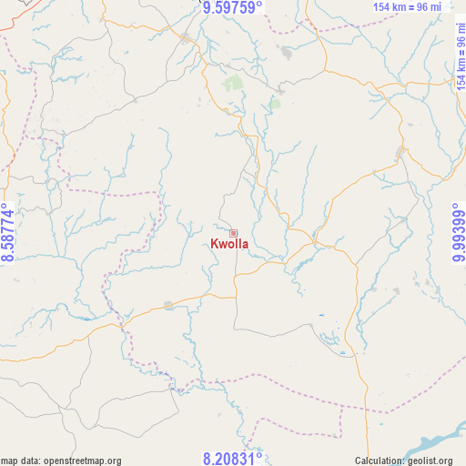
Kwolla GPS coordinates[2]
8° 54' 12.996" North, 9° 17' 27.096" East
| Map corner | latitude | longitude |
|---|---|---|
| Upper-left | 9.59759°, | 8.58774° |
| Center: | 8.90361°, | 9.29086° |
| Lower-right: | 8.20831°, | 9.99399° |
| Map W x H: | 154.5×154.5 km | = 96×96mi |
| max Lat: | 13.7543° ⇑46% North |
| Kwolla: | 8.90361° |
| min Lat: | ⇓54% South 4.31231° |
| min Long | Kwolla | max Long |
| 2.73333° | 9.29086° | 14.46552° |
| W 79.3%⇐ | ⇒20.7% E |
Elevation
Elevation of Kwolla is 269 m = 883 ft, and this is 27.5 m = 90 ft below average elevation for this country.
| Max E: |
1599 m = 5246 ft | 52.6% |
| Avg. | 296.5 m = 973 ft | |
| Kwolla | 269 m = 883 ft | |
Min E: |
2 m = 7 ft | 47.4% |
See also: Nigeria elevation on elevation.city.
Geographical zone
Kwolla is located in North Torrid zone (between Equator and Tropic of Cancer). Distance of Equator is 990 km =615.2 mi to South.| Distance of | km | miles | from Kwolla |
|---|---|---|---|
| North Pole | 9017.1 | 5603 | to North |
| Arctic Circle | 6411.2 | 3983.7 | to North |
| Tropic Cancer | 1615.9 | 1004.1 | to North |
| Equator | 990 | 615.2 | to South |


Nearby cities:
15 places around Kwolla: (largest is in red/bold)
• Amper
67.4 km =41.9 mi,  41°
41°
• Baap
7 km =4.3 mi,  308°
308°
• Boi
76.7 km =47.7 mi,  17°
17°
• Bokkos
54.7 km =34 mi,  323°
323°
• Kwal
63.3 km =39.3 mi,  34°
34°
• Langtang
61 km =37.9 mi,  64°
64°
• Mabudi
57.6 km =35.8 mi,  109°
109°
• Mangu
71.8 km =44.6 mi,  342°
342°
• Pankshin
49.5 km =30.8 mi, 18°
• Panyam
56.7 km =35.2 mi,  351°
351°
• Shendam
26.9 km =16.7 mi,  95°
95°
• Tunkus
37.8 km =23.5 mi,  69°
69°
• Wamba
75.7 km =47 mi,  273°
273°
• Wase
76.1 km =47.3 mi, 73°
• Yelwa
38.4 km =23.9 mi, 101°
Sources, notices
• [Note1] Compared only with cities in Nigeria existing in our database
• [Src1] Map data: © OpenStreetMap contributors (CC-BY-SA)
• [Src2] Other city data from geonames.org with taken over terms of usage.
• [Src3] Geographical zone / Annual Mean Temperature by Robert A. Rohde @ Wikipedia
