Illela geodata
Illela (Sokoto) is a seat of a second-order administrative division; located in Nigeria in Africa/Lagos (GMT+1) time zone. With population of 17,461 people, there are 217 cities with bigger population in this country. Compared to other cities in Nigeria, 99.9% of cities are located further ↓South; 77.2% of cities are located further →East and 51.7% of cities have higher elevation than Illela. Note1


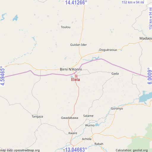
Illela GPS coordinates[2]
13° 43' 50.304" North, 5° 17' 51.972" East
| Map corner | latitude | longitude |
|---|---|---|
| Upper-left | 14.41266°, | 4.59465° |
| Center: | 13.73064°, | 5.29777° |
| Lower-right: | 13.04663°, | 6.0009° |
| Map W x H: | 151.9×151.9 km | = 94.4×94.4mi |
| max Lat: | 13.7543° ⇑0.1% North |
| Illela: | 13.73064° |
| min Lat: | ⇓99.9% South 4.31231° |
| min Long | Illela | max Long |
| 2.73333° | 5.29777° | 14.46552° |
| W 22.8%⇐ | ⇒77.2% E |
Elevation
Elevation of Illela is 272 m = 892 ft, and this is 24.5 m = 80 ft below average elevation for this country.
| Max E: |
1599 m = 5246 ft | 51.7% |
| Avg. | 296.5 m = 973 ft | |
| Illela | 272 m = 892 ft | |
Min E: |
2 m = 7 ft | 48.3% |
See also: Nigeria elevation on elevation.city.
Geographical zone
Illela is located in North Torrid zone (between Equator and Tropic of Cancer). Distance of this Northern Tropic circle is 1079.2 km =670.6 mi to North.| Distance of | km | miles | from Illela |
|---|---|---|---|
| North Pole | 8480.4 | 5269.5 | to North |
| Arctic Circle | 5874.5 | 3650.2 | to North |
| Tropic Cancer | 1079.2 | 670.6 | to North |
| Equator | 1526.7 | 948.6 | to South |


Nearby cities:
15 places around Illela: (largest is in red/bold)
• Balle
72.7 km =45.2 mi,  246°
246°
• Binji
70.4 km =43.7 mi,  216°
216°
• Bodinga
99.9 km =62.1 mi,  189°
189°
• Dange
97.7 km =60.7 mi,  176°
176°
• Gada
38.9 km =24.2 mi,  86°
86°
• Gandi
98 km =60.9 mi,  150°
150°
• Gidan Madi
59.7 km =37.1 mi, 215°
• Goronyo
51.6 km =32.1 mi,  128°
128°
• Gwadabawa
41.9 km =26 mi, 188°
• Kware
56.9 km =35.4 mi, 183°
• Rabah
71.3 km =44.3 mi,  161°
161°
• Silame
91.1 km =56.6 mi,  212°
212°
• Sokoto
74.5 km =46.3 mi, 184°
• Wamako
80.6 km =50.1 mi,  195°
195°
• Wurno
50.8 km =31.6 mi, 164°
Sources, notices
• [Note1] Compared only with cities in Nigeria existing in our database
• [Src1] Map data: © OpenStreetMap contributors (CC-BY-SA)
• [Src2] Other city data from geonames.org with taken over terms of usage.
• [Src3] Geographical zone / Annual Mean Temperature by Robert A. Rohde @ Wikipedia
