Argungu geodata
Argungu (Kebbi) is a seat of a second-order administrative division; located in Nigeria in Africa/Lagos (GMT+1) time zone. With population of 45,584 people, there are 150 cities with bigger population in this country. Compared to other cities in Nigeria, 94% of cities are located further ↓South; 87.3% of cities are located further →East and 57.3% of cities have higher elevation than Argungu. Note1


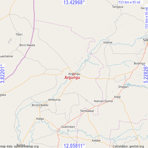
Argungu GPS coordinates[2]
12° 44' 41.352" North, 4° 31' 30.504" East
| Map corner | latitude | longitude |
|---|---|---|
| Upper-left | 13.42968°, | 3.82201° |
| Center: | 12.74482°, | 4.52514° |
| Lower-right: | 12.05811°, | 5.22826° |
| Map W x H: | 152.5×152.5 km | = 94.8×94.8mi |
| max Lat: | 13.7543° ⇑6% North |
| Argungu: | 12.74482° |
| min Lat: | ⇓94% South 4.31231° |
| min Long | Argungu | max Long |
| 2.73333° | 4.52514° | 14.46552° |
| W 12.7%⇐ | ⇒87.3% E |
Elevation
Elevation of Argungu is 228 m = 748 ft, and this is 68.5 m = 225 ft below average elevation for this country.
| Max E: |
1599 m = 5246 ft | 57.3% |
| Avg. | 296.5 m = 973 ft | |
| Argungu | 228 m = 748 ft | |
Min E: |
2 m = 7 ft | 42.7% |
See also: Argungu elevation on elevation.city.
Geographical zone
Argungu is located in North Torrid zone (between Equator and Tropic of Cancer). Distance of this Northern Tropic circle is 1188.8 km =738.7 mi to North.| Distance of | km | miles | from Argungu |
|---|---|---|---|
| North Pole | 8590 | 5337.6 | to North |
| Arctic Circle | 5984.1 | 3718.3 | to North |
| Tropic Cancer | 1188.8 | 738.7 | to North |
| Equator | 1417.1 | 880.5 | to South |


Nearby cities:
15 places around Argungu: (largest is in red/bold)
• Aliero
51.1 km =31.8 mi,  186°
186°
• Augie
18.1 km =11.2 mi,  26°
26°
• Binji
67.5 km =41.9 mi,  38°
38°
• Birnin Kebbi
48.1 km =29.9 mi,  227°
227°
• Bodinga
68.6 km =42.6 mi,  80°
80°
• Gulma
21.6 km =13.4 mi,  238°
238°
• Gwandu
29.9 km =18.6 mi,  154°
154°
• Jega
60.1 km =37.3 mi,  195°
195°
• Kalgo
58.3 km =36.2 mi,  217°
217°
• Kebbe
72.2 km =44.9 mi,  161°
161°
• Shagari
52.4 km =32.6 mi,  104°
104°
• Silame
47.8 km =29.7 mi,  46°
46°
• Tambuwal
39.9 km =24.8 mi, 160°
• Wamako
70.4 km =43.7 mi,  63°
63°
• Yabo
53 km =32.9 mi,  92°
92°
Sources, notices
• [Note1] Compared only with cities in Nigeria existing in our database
• [Src1] Map data: © OpenStreetMap contributors (CC-BY-SA)
• [Src2] Other city data from geonames.org with taken over terms of usage.
• [Src3] Geographical zone / Annual Mean Temperature by Robert A. Rohde @ Wikipedia
