Gulma geodata
Gulma (Kebbi) is a populated place; located in Nigeria in Africa/Lagos (GMT+1) time zone. With population of 6,719 people, there are 425 cities with bigger population in this country. Compared to other cities in Nigeria, 92.5% of cities are located further ↓South; 89.1% of cities are located further →East and 59.3% of cities have higher elevation than Gulma. Note1


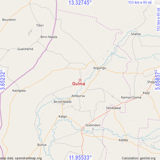
Gulma GPS coordinates[2]
12° 38' 32.316" North, 4° 21' 19.62" East
| Map corner | latitude | longitude |
|---|---|---|
| Upper-left | 13.32745°, | 3.65232° |
| Center: | 12.64231°, | 4.35545° |
| Lower-right: | 11.95533°, | 5.05857° |
| Map W x H: | 152.6×152.6 km | = 94.8×94.8mi |
| max Lat: | 13.7543° ⇑7.5% North |
| Gulma: | 12.64231° |
| min Lat: | ⇓92.5% South 4.31231° |
| min Long | Gulma | max Long |
| 2.73333° | 4.35545° | 14.46552° |
| W 10.9%⇐ | ⇒89.1% E |
Elevation
Elevation of Gulma is 214 m = 702 ft, and this is 82.5 m = 271 ft below average elevation for this country.
| Max E: |
1599 m = 5246 ft | 59.3% |
| Avg. | 296.5 m = 973 ft | |
| Gulma | 214 m = 702 ft | |
Min E: |
2 m = 7 ft | 40.7% |
See also: Nigeria elevation on elevation.city.
Geographical zone
Gulma is located in North Torrid zone (between Equator and Tropic of Cancer). Distance of this Northern Tropic circle is 1200.2 km =745.8 mi to North.| Distance of | km | miles | from Gulma |
|---|---|---|---|
| North Pole | 8601.4 | 5344.7 | to North |
| Arctic Circle | 5995.5 | 3725.4 | to North |
| Tropic Cancer | 1200.2 | 745.8 | to North |
| Equator | 1405.7 | 873.5 | to South |


Nearby cities:
15 places around Gulma: (largest is in red/bold)
• Aliero
41.3 km =25.7 mi,  162°
162°
• Argungu
21.6 km =13.4 mi,  58°
58°
• Augie
38.2 km =23.7 mi,  43°
43°
• Birnin Kebbi
27.1 km =16.8 mi,  219°
219°
• Bunza
71.8 km =44.6 mi,  210°
210°
• Gwandu
34.9 km =21.7 mi,  116°
116°
• Jega
46.7 km =29 mi,  176°
176°
• Kalgo
38.9 km =24.2 mi, 205°
• Kangiwa
59.1 km =36.7 mi,  260°
260°
• Kebbe
70.4 km =43.7 mi,  144°
144°
• Maiyama
62.3 km =38.7 mi, 178°
• Shagari
69.2 km =43 mi,  91°
91°
• Silame
69.1 km =42.9 mi,  50°
50°
• Tambuwal
41.1 km =25.5 mi,  129°
129°
• Yabo
71.9 km =44.7 mi,  82°
82°
Sources, notices
• [Note1] Compared only with cities in Nigeria existing in our database
• [Src1] Map data: © OpenStreetMap contributors (CC-BY-SA)
• [Src2] Other city data from geonames.org with taken over terms of usage.
• [Src3] Geographical zone / Annual Mean Temperature by Robert A. Rohde @ Wikipedia
