Lamurde geodata
Lamurde (Adamawa) is a seat of a second-order administrative division; located in Nigeria in Africa/Lagos (GMT+1) time zone. In our database, there are 451 cities with bigger population. Compared to other cities in Nigeria, 60.6% of cities are located further ↓South; 93% of cities are located further ←West and 64.6% of cities have higher elevation than Lamurde. Note1


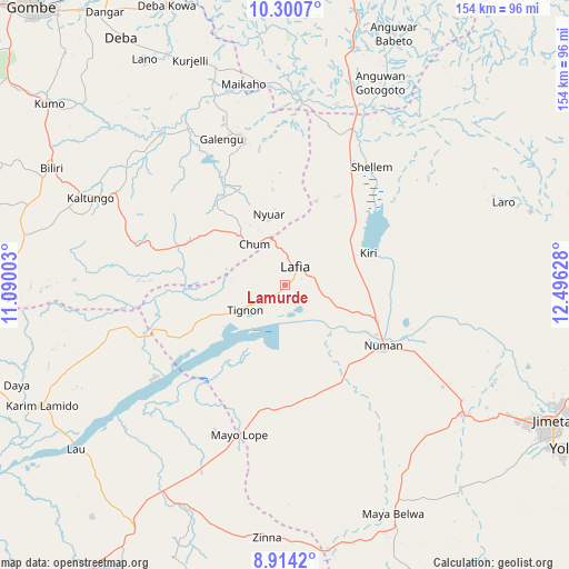
Lamurde GPS coordinates[2]
9° 36' 29.376" North, 11° 47' 35.34" East
| Map corner | latitude | longitude |
|---|---|---|
| Upper-left | 10.3007°, | 11.09003° |
| Center: | 9.60816°, | 11.79315° |
| Lower-right: | 8.9142°, | 12.49628° |
| Map W x H: | 154.2×154.2 km | = 95.8×95.8mi |
| max Lat: | 13.7543° ⇑39.4% North |
| Lamurde: | 9.60816° |
| min Lat: | ⇓60.6% South 4.31231° |
| min Long | Lamurde | max Long |
| 2.73333° | 11.79315° | 14.46552° |
| W 93%⇐ | ⇒7% E |
Elevation
Elevation of Lamurde is 180 m = 591 ft, and this is 116.5 m = 382 ft below average elevation for this country.
| Max E: |
1599 m = 5246 ft | 64.6% |
| Avg. | 296.5 m = 973 ft | |
| Lamurde | 180 m = 591 ft | |
Min E: |
2 m = 7 ft | 35.4% |
See also: Nigeria elevation on elevation.city.
Geographical zone
Lamurde is located in North Torrid zone (between Equator and Tropic of Cancer). Distance of Equator is 1068.3 km =663.8 mi to South.| Distance of | km | miles | from Lamurde |
|---|---|---|---|
| North Pole | 8938.7 | 5554.2 | to North |
| Arctic Circle | 6332.8 | 3935 | to North |
| Tropic Cancer | 1537.6 | 955.4 | to North |
| Equator | 1068.3 | 663.8 | to South |


Nearby cities:
15 places around Lamurde: (largest is in red/bold)
• Billiri
68.4 km =42.5 mi,  294°
294°
• Billiri
70.4 km =43.7 mi,  296°
296°
• Boh
59.6 km =37 mi, 288°
• Dadiya
39.5 km =24.5 mi,  271°
271°
• Demsa
42.9 km =26.7 mi,  113°
113°
• Guyuk
36.3 km =22.6 mi,  23°
23°
• Kaltungo
58.1 km =36.1 mi, 293°
• Lau
72.1 km =44.8 mi,  231°
231°
• Mayo-Belwa
68.1 km =42.3 mi,  154°
154°
• Ngurore
60.6 km =37.7 mi,  125°
125°
• Numan
30.6 km =19 mi,  121°
121°
• Shani
73.9 km =45.9 mi, 23°
• Shelleng
39.6 km =24.6 mi,  36°
36°
• Talasse
42 km =26.1 mi,  342°
342°
• Zing
68.8 km =42.8 mi,  184°
184°
Sources, notices
• [Note1] Compared only with cities in Nigeria existing in our database
• [Src1] Map data: © OpenStreetMap contributors (CC-BY-SA)
• [Src2] Other city data from geonames.org with taken over terms of usage.
• [Src3] Geographical zone / Annual Mean Temperature by Robert A. Rohde @ Wikipedia
