Boh geodata
Boh (Gombe) is a seat of a second-order administrative division; located in Nigeria in Africa/Lagos (GMT+1) time zone. In our database, there are 451 cities with bigger population. Compared to other cities in Nigeria, 62% of cities are located further ↓South; 90.6% of cities are located further ←West and 90.8% of cities have lower elevation than Boh. Note1


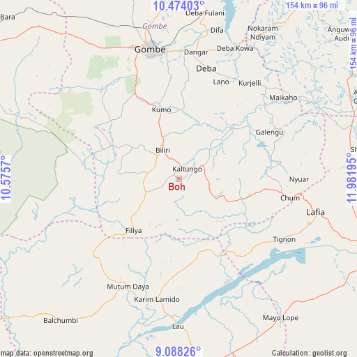
Boh GPS coordinates[2]
9° 46' 54.732" North, 11° 16' 43.752" East
| Map corner | latitude | longitude |
|---|---|---|
| Upper-left | 10.47403°, | 10.5757° |
| Center: | 9.78187°, | 11.27882° |
| Lower-right: | 9.08826°, | 11.98195° |
| Map W x H: | 154.1×154.1 km | = 95.8×95.8mi |
| max Lat: | 13.7543° ⇑38% North |
| Boh: | 9.78187° |
| min Lat: | ⇓62% South 4.31231° |
| min Long | Boh | max Long |
| 2.73333° | 11.27882° | 14.46552° |
| W 90.6%⇐ | ⇒9.4% E |
Elevation
Elevation of Boh is 568 m = 1864 ft, and this is 271.5 m = 891 ft above average elevation for this country.
| Max E: |
1599 m = 5246 ft | 9.2% |
| Boh | 568 m 1864 ft | |
| Avg. | 296.5 m = 973 ft | |
Min E: |
2 m = 7 ft | 90.8% |
See also: Nigeria elevation on elevation.city.
Geographical zone
Boh is located in North Torrid zone (between Equator and Tropic of Cancer). Distance of Equator is 1087.6 km =675.8 mi to South.| Distance of | km | miles | from Boh |
|---|---|---|---|
| North Pole | 8919.4 | 5542.3 | to North |
| Arctic Circle | 6313.5 | 3923 | to North |
| Tropic Cancer | 1518.3 | 943.4 | to North |
| Equator | 1087.6 | 675.8 | to South |


Nearby cities:
15 places around Boh: (largest is in red/bold)
• Akko
65.6 km =40.8 mi,  329°
329°
• Billiri
10.9 km =6.8 mi, 328°
• Billiri
13.8 km =8.6 mi, 331°
• Dadiya
25 km =15.5 mi,  137°
137°
• Deba
49.3 km =30.6 mi,  13°
13°
• Garko
45.5 km =28.3 mi,  344°
344°
• Gombe
57.8 km =35.9 mi,  347°
347°
• Hinna
62.9 km =39.1 mi,  22°
22°
• Kaltungo
5.4 km =3.4 mi,  37°
37°
• Karim Lamido
52.9 km =32.9 mi,  190°
190°
• Kumo
30.5 km =19 mi, 345°
• Lamurde
59.6 km =37 mi,  108°
108°
• Lau
63.8 km =39.6 mi,  180°
180°
• Pindiga
42.3 km =26.3 mi,  302°
302°
• Talasse
48.5 km =30.1 mi,  64°
64°
Sources, notices
• [Note1] Compared only with cities in Nigeria existing in our database
• [Src1] Map data: © OpenStreetMap contributors (CC-BY-SA)
• [Src2] Other city data from geonames.org with taken over terms of usage.
• [Src3] Geographical zone / Annual Mean Temperature by Robert A. Rohde @ Wikipedia
