Sauri geodata
Sauri (Zamfara) is a populated place; located in Nigeria in Africa/Lagos (GMT+1) time zone. With population of 13,445 people, there are 265 cities with bigger population in this country. Compared to other cities in Nigeria, 80.9% of cities are located further ↓South; 61% of cities are located further →East and 93.5% of cities have lower elevation than Sauri. Note1


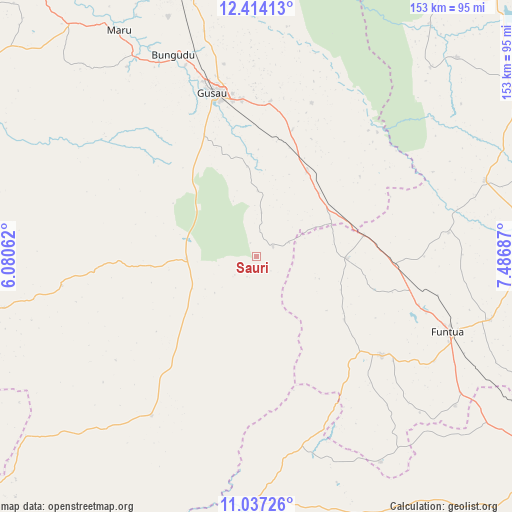
Sauri GPS coordinates[2]
11° 43' 35.58" North, 6° 47' 1.464" East
| Map corner | latitude | longitude |
|---|---|---|
| Upper-left | 12.41413°, | 6.08062° |
| Center: | 11.72655°, | 6.78374° |
| Lower-right: | 11.03726°, | 7.48687° |
| Map W x H: | 153.1×153.1 km | = 95.1×95.1mi |
| max Lat: | 13.7543° ⇑19.1% North |
| Sauri: | 11.72655° |
| min Lat: | ⇓80.9% South 4.31231° |
| min Long | Sauri | max Long |
| 2.73333° | 6.78374° | 14.46552° |
| W 39%⇐ | ⇒61% E |
Elevation
Elevation of Sauri is 612 m = 2008 ft, and this is 315.5 m = 1035 ft above average elevation for this country.
| Max E: |
1599 m = 5246 ft | 6.5% |
| Sauri | 612 m 2008 ft | |
| Avg. | 296.5 m = 973 ft | |
Min E: |
2 m = 7 ft | 93.5% |
See also: Nigeria elevation on elevation.city.
Geographical zone
Sauri is located in North Torrid zone (between Equator and Tropic of Cancer). Distance of this Northern Tropic circle is 1302 km =809 mi to North.| Distance of | km | miles | from Sauri |
|---|---|---|---|
| North Pole | 8703.2 | 5407.9 | to North |
| Arctic Circle | 6097.3 | 3788.7 | to North |
| Tropic Cancer | 1302 | 809 | to North |
| Equator | 1303.9 | 810.2 | to South |


Nearby cities:
15 places around Sauri: (largest is in red/bold)
• Bakori
72.3 km =44.9 mi,  105°
105°
• Bungudu
65.3 km =40.6 mi,  337°
337°
• Dan Musa
84.4 km =52.4 mi,  45°
45°
• Dan Sadau
57.3 km =35.6 mi,  213°
213°
• Dandume
47.7 km =29.6 mi,  128°
128°
• Faskari
26.8 km =16.7 mi,  91°
91°
• Funtua
61.8 km =38.4 mi, 111°
• Giwa
85.7 km =53.3 mi,  122°
122°
• Gusau
51 km =31.7 mi,  345°
345°
• Kankara
72 km =44.7 mi,  71°
71°
• Kwatarkwashi
46.2 km =28.7 mi,  5°
5°
• Maru
79.1 km =49.2 mi,  328°
328°
• Sabuwa
71.6 km =44.5 mi,  149°
149°
• Sofo-Birnin-Gwari
79.1 km =49.2 mi,  180°
180°
• Tsafe
29.7 km =18.5 mi,  30°
30°
Sources, notices
• [Note1] Compared only with cities in Nigeria existing in our database
• [Src1] Map data: © OpenStreetMap contributors (CC-BY-SA)
• [Src2] Other city data from geonames.org with taken over terms of usage.
• [Src3] Geographical zone / Annual Mean Temperature by Robert A. Rohde @ Wikipedia
