Kwatarkwashi geodata
Kwatarkwashi (Zamfara) is a populated place; located in Nigeria in Africa/Lagos (GMT+1) time zone. With population of 9,084 people, there are 355 cities with bigger population in this country. Compared to other cities in Nigeria, 86.1% of cities are located further ↓South; 60.2% of cities are located further →East and 81.7% of cities have lower elevation than Kwatarkwashi. Note1


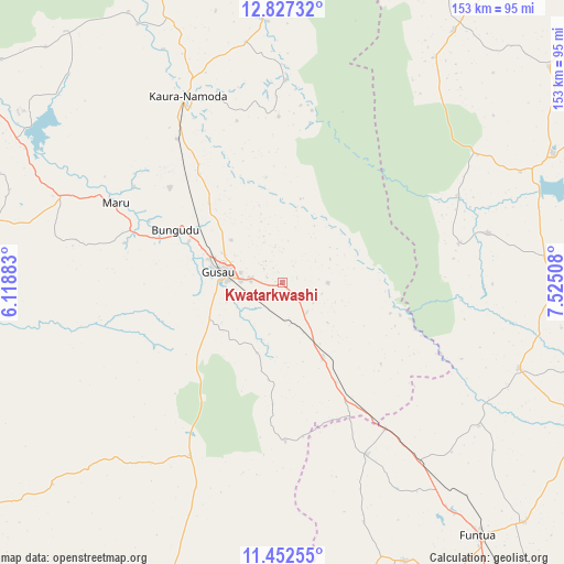
Kwatarkwashi GPS coordinates[2]
12° 8' 26.952" North, 6° 49' 19.056" East
| Map corner | latitude | longitude |
|---|---|---|
| Upper-left | 12.82732°, | 6.11883° |
| Center: | 12.14082°, | 6.82196° |
| Lower-right: | 11.45255°, | 7.52508° |
| Map W x H: | 152.9×152.9 km | = 95×95mi |
| max Lat: | 13.7543° ⇑13.9% North |
| Kwatarkwashi: | 12.14082° |
| min Lat: | ⇓86.1% South 4.31231° |
| min Long | Kwatarkwashi | max Long |
| 2.73333° | 6.82196° | 14.46552° |
| W 39.8%⇐ | ⇒60.2% E |
Elevation
Elevation of Kwatarkwashi is 483 m = 1585 ft, and this is 186.5 m = 612 ft above average elevation for this country.
| Max E: |
1599 m = 5246 ft | 18.3% |
| Kwatarkwashi | 483 m 1585 ft | |
| Avg. | 296.5 m = 973 ft | |
Min E: |
2 m = 7 ft | 81.7% |
See also: Nigeria elevation on elevation.city.
Geographical zone
Kwatarkwashi is located in North Torrid zone (between Equator and Tropic of Cancer). Distance of this Northern Tropic circle is 1256 km =780.4 mi to North.| Distance of | km | miles | from Kwatarkwashi |
|---|---|---|---|
| North Pole | 8657.1 | 5379.3 | to North |
| Arctic Circle | 6051.2 | 3760 | to North |
| Tropic Cancer | 1256 | 780.4 | to North |
| Equator | 1349.9 | 838.8 | to South |


Nearby cities:
15 places around Kwatarkwashi: (largest is in red/bold)
• Birnin Magaji
47.2 km =29.3 mi,  9°
9°
• Bungudu
32.5 km =20.2 mi,  295°
295°
• Dan Musa
57.3 km =35.6 mi,  76°
76°
• Faskari
51.9 km =32.2 mi,  154°
154°
• Gusau
17.5 km =10.9 mi,  280°
280°
• Kankara
68.2 km =42.4 mi,  109°
109°
• Kaura Namoda
56.5 km =35.1 mi,  333°
333°
• Maradun
78.6 km =48.8 mi,  307°
307°
• Maru
50.2 km =31.2 mi, 295°
• Runka
63 km =39.1 mi,  57°
57°
• Safana
71 km =44.1 mi,  65°
65°
• Sauri
46.2 km =28.7 mi,  185°
185°
• Tsafe
23 km =14.3 mi, 152°
• Wagini
73.1 km =45.4 mi,  33°
33°
• Zurmi
70.8 km =44 mi,  356°
356°
Sources, notices
• [Note1] Compared only with cities in Nigeria existing in our database
• [Src1] Map data: © OpenStreetMap contributors (CC-BY-SA)
• [Src2] Other city data from geonames.org with taken over terms of usage.
• [Src3] Geographical zone / Annual Mean Temperature by Robert A. Rohde @ Wikipedia
