Kankara geodata
Kankara (Katsina) is a seat of a second-order administrative division; located in Nigeria in Africa/Lagos (GMT+1) time zone. With population of 9,609 people, there are 341 cities with bigger population in this country. Compared to other cities in Nigeria, 83.6% of cities are located further ↓South; 51.8% of cities are located further ←West and 92.8% of cities have lower elevation than Kankara. Note1


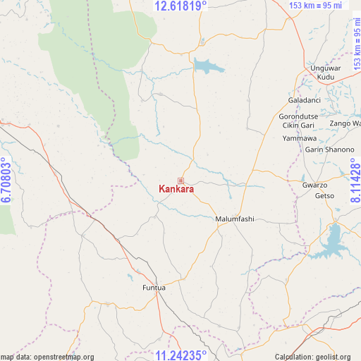
Kankara GPS coordinates[2]
11° 55' 52.104" North, 7° 24' 40.14" East
| Map corner | latitude | longitude |
|---|---|---|
| Upper-left | 12.61819°, | 6.70803° |
| Center: | 11.93114°, | 7.41115° |
| Lower-right: | 11.24235°, | 8.11428° |
| Map W x H: | 153×153 km | = 95.1×95.1mi |
| max Lat: | 13.7543° ⇑16.4% North |
| Kankara: | 11.93114° |
| min Lat: | ⇓83.6% South 4.31231° |
| min Long | Kankara | max Long |
| 2.73333° | 7.41115° | 14.46552° |
| W 51.8%⇐ | ⇒48.2% E |
Elevation
Elevation of Kankara is 595 m = 1952 ft, and this is 298.5 m = 979 ft above average elevation for this country.
| Max E: |
1599 m = 5246 ft | 7.2% |
| Kankara | 595 m 1952 ft | |
| Avg. | 296.5 m = 973 ft | |
Min E: |
2 m = 7 ft | 92.8% |
See also: Nigeria elevation on elevation.city.
Geographical zone
Kankara is located in North Torrid zone (between Equator and Tropic of Cancer). Distance of this Northern Tropic circle is 1279.3 km =794.9 mi to North.| Distance of | km | miles | from Kankara |
|---|---|---|---|
| North Pole | 8680.4 | 5393.7 | to North |
| Arctic Circle | 6074.6 | 3774.6 | to North |
| Tropic Cancer | 1279.3 | 794.9 | to North |
| Equator | 1326.6 | 824.3 | to South |


Nearby cities:
15 places around Kankara: (largest is in red/bold)
• Bakori
41.8 km =26 mi,  178°
178°
• Dan Musa
37.7 km =23.4 mi,  347°
347°
• Dutsin-Ma
58.9 km =36.6 mi,  9°
9°
• Faskari
47.6 km =29.6 mi,  240°
240°
• Funtua
46.6 km =29 mi,  193°
193°
• Gora
27.7 km =17.2 mi,  94°
94°
• Gwarzo
56.9 km =35.4 mi, 91°
• Jikamshi
47.8 km =29.7 mi,  55°
55°
• Kafur
44 km =27.3 mi,  136°
136°
• Malumfashi
27.7 km =17.2 mi,  124°
124°
• Matazu
44.3 km =27.5 mi,  40°
40°
• Musawa
35.8 km =22.2 mi,  51°
51°
• Runka
58.5 km =36.4 mi, 349°
• Safana
53.3 km =33.1 mi,  0°
0°
• Tsafe
53.4 km =33.2 mi,  273°
273°
Sources, notices
• [Note1] Compared only with cities in Nigeria existing in our database
• [Src1] Map data: © OpenStreetMap contributors (CC-BY-SA)
• [Src2] Other city data from geonames.org with taken over terms of usage.
• [Src3] Geographical zone / Annual Mean Temperature by Robert A. Rohde @ Wikipedia
