Funtua geodata
Funtua (Katsina) is a seat of a second-order administrative division; located in Nigeria in Africa/Lagos (GMT+1) time zone. With population of 136,811 people, there are 60 cities with bigger population in this country. Compared to other cities in Nigeria, 78% of cities are located further ↓South; 50.5% of cities are located further →East and 96.8% of cities have lower elevation than Funtua. Note1


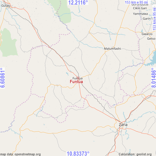
Funtua GPS coordinates[2]
11° 31' 24.636" North, 7° 18' 42.264" East
| Map corner | latitude | longitude |
|---|---|---|
| Upper-left | 12.2116°, | 6.60861° |
| Center: | 11.52351°, | 7.31174° |
| Lower-right: | 10.83373°, | 8.01486° |
| Map W x H: | 153.2×153.2 km | = 95.2×95.2mi |
| max Lat: | 13.7543° ⇑22% North |
| Funtua: | 11.52351° |
| min Lat: | ⇓78% South 4.31231° |
| min Long | Funtua | max Long |
| 2.73333° | 7.31174° | 14.46552° |
| W 49.5%⇐ | ⇒50.5% E |
Elevation
Elevation of Funtua is 709 m = 2326 ft, and this is 412.5 m = 1353 ft above average elevation for this country.
| Max E: |
1599 m = 5246 ft | 3.2% |
| Funtua | 709 m 2326 ft | |
| Avg. | 296.5 m = 973 ft | |
Min E: |
2 m = 7 ft | 96.8% |
See also: Funtua elevation on elevation.city.
Geographical zone
Funtua is located in North Torrid zone (between Equator and Tropic of Cancer). Distance of Equator is 1281.3 km =796.2 mi to South.| Distance of | km | miles | from Funtua |
|---|---|---|---|
| North Pole | 8725.8 | 5422 | to North |
| Arctic Circle | 6119.9 | 3802.7 | to North |
| Tropic Cancer | 1324.6 | 823.1 | to North |
| Equator | 1281.3 | 796.2 | to South |


Nearby cities:
15 places around Funtua: (largest is in red/bold)
• Bakori
12.8 km =8 mi,  73°
73°
• Dandume
21.5 km =13.4 mi,  250°
250°
• Danja
31.7 km =19.7 mi,  120°
120°
• Faskari
37.7 km =23.4 mi,  305°
305°
• Giwa
27.6 km =17.1 mi,  146°
146°
• Gora
57.9 km =36 mi,  41°
41°
• Hunkuyi
46.6 km =29 mi,  127°
127°
• Kafur
43.5 km =27 mi, 71°
• Kankara
46.6 km =29 mi,  13°
13°
• Makarfi
64.1 km =39.8 mi,  104°
104°
• Malumfashi
44.8 km =27.8 mi,  48°
48°
• Rogo
55.7 km =34.6 mi,  86°
86°
• Sabuwa
44.1 km =27.4 mi,  208°
208°
• Sauri
61.8 km =38.4 mi,  291°
291°
• Zaria
64.1 km =39.8 mi,  135°
135°
Sources, notices
• [Note1] Compared only with cities in Nigeria existing in our database
• [Src1] Map data: © OpenStreetMap contributors (CC-BY-SA)
• [Src2] Other city data from geonames.org with taken over terms of usage.
• [Src3] Geographical zone / Annual Mean Temperature by Robert A. Rohde @ Wikipedia
