Tsafe geodata
Tsafe (Zamfara) is a seat of a second-order administrative division; located in Nigeria in Africa/Lagos (GMT+1) time zone. With population of 9,367 people, there are 346 cities with bigger population in this country. Compared to other cities in Nigeria, 83.8% of cities are located further ↓South; 58.5% of cities are located further →East and 90.5% of cities have lower elevation than Tsafe. Note1


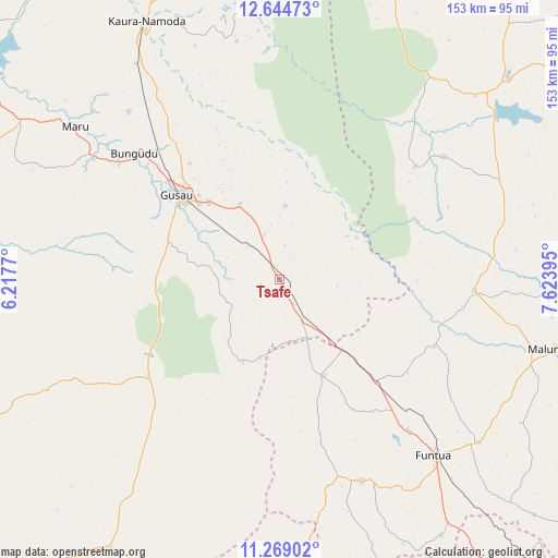
Tsafe GPS coordinates[2]
11° 57' 27.9" North, 6° 55' 14.988" East
| Map corner | latitude | longitude |
|---|---|---|
| Upper-left | 12.64473°, | 6.2177° |
| Center: | 11.95775°, | 6.92083° |
| Lower-right: | 11.26902°, | 7.62395° |
| Map W x H: | 153×153 km | = 95.1×95.1mi |
| max Lat: | 13.7543° ⇑16.2% North |
| Tsafe: | 11.95775° |
| min Lat: | ⇓83.8% South 4.31231° |
| min Long | Tsafe | max Long |
| 2.73333° | 6.92083° | 14.46552° |
| W 41.5%⇐ | ⇒58.5% E |
Elevation
Elevation of Tsafe is 565 m = 1854 ft, and this is 268.5 m = 881 ft above average elevation for this country.
| Max E: |
1599 m = 5246 ft | 9.5% |
| Tsafe | 565 m 1854 ft | |
| Avg. | 296.5 m = 973 ft | |
Min E: |
2 m = 7 ft | 90.5% |
See also: Nigeria elevation on elevation.city.
Geographical zone
Tsafe is located in North Torrid zone (between Equator and Tropic of Cancer). Distance of this Northern Tropic circle is 1276.3 km =793.1 mi to North.| Distance of | km | miles | from Tsafe |
|---|---|---|---|
| North Pole | 8677.5 | 5391.9 | to North |
| Arctic Circle | 6071.6 | 3772.7 | to North |
| Tropic Cancer | 1276.3 | 793.1 | to North |
| Equator | 1329.6 | 826.2 | to South |


Nearby cities:
15 places around Tsafe: (largest is in red/bold)
• Bakori
70.7 km =43.9 mi,  129°
129°
• Birnin Magaji
66.9 km =41.6 mi,  357°
357°
• Bungudu
52.9 km =32.9 mi,  310°
310°
• Dan Musa
56.2 km =34.9 mi,  53°
53°
• Dandume
59.8 km =37.2 mi,  158°
158°
• Faskari
28.9 km =18 mi, 155°
• Funtua
64.4 km =40 mi,  138°
138°
• Gusau
36.6 km =22.7 mi, 310°
• Kankara
53.4 km =33.2 mi,  93°
93°
• Kwatarkwashi
23 km =14.3 mi,  332°
332°
• Malumfashi
78.4 km =48.7 mi,  103°
103°
• Maru
70 km =43.5 mi, 306°
• Runka
68.9 km =42.8 mi,  37°
37°
• Safana
73.6 km =45.7 mi, 46°
• Sauri
29.7 km =18.5 mi,  210°
210°
Sources, notices
• [Note1] Compared only with cities in Nigeria existing in our database
• [Src1] Map data: © OpenStreetMap contributors (CC-BY-SA)
• [Src2] Other city data from geonames.org with taken over terms of usage.
• [Src3] Geographical zone / Annual Mean Temperature by Robert A. Rohde @ Wikipedia
