Giwa geodata
Giwa (Kaduna) is a seat of a second-order administrative division; located in Nigeria in Africa/Lagos (GMT+1) time zone. In our database, there are 451 cities with bigger population. Compared to other cities in Nigeria, 75.5% of cities are located further ↓South; 52.6% of cities are located further ←West and 95.9% of cities have lower elevation than Giwa. Note1


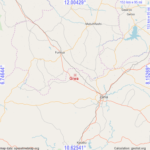
Giwa GPS coordinates[2]
11° 18' 56.448" North, 7° 26' 58.452" East
| Map corner | latitude | longitude |
|---|---|---|
| Upper-left | 12.00429°, | 6.74644° |
| Center: | 11.31568°, | 7.44957° |
| Lower-right: | 10.62541°, | 8.15269° |
| Map W x H: | 153.3×153.3 km | = 95.3×95.3mi |
| max Lat: | 13.7543° ⇑24.5% North |
| Giwa: | 11.31568° |
| min Lat: | ⇓75.5% South 4.31231° |
| min Long | Giwa | max Long |
| 2.73333° | 7.44957° | 14.46552° |
| W 52.6%⇐ | ⇒47.4% E |
Elevation
Elevation of Giwa is 680 m = 2231 ft, and this is 383.5 m = 1258 ft above average elevation for this country.
| Max E: |
1599 m = 5246 ft | 4.1% |
| Giwa | 680 m 2231 ft | |
| Avg. | 296.5 m = 973 ft | |
Min E: |
2 m = 7 ft | 95.9% |
See also: Nigeria elevation on elevation.city.
Geographical zone
Giwa is located in North Torrid zone (between Equator and Tropic of Cancer). Distance of Equator is 1258.2 km =781.8 mi to South.| Distance of | km | miles | from Giwa |
|---|---|---|---|
| North Pole | 8748.9 | 5436.3 | to North |
| Arctic Circle | 6143 | 3817.1 | to North |
| Tropic Cancer | 1347.7 | 837.4 | to North |
| Equator | 1258.2 | 781.8 | to South |


Nearby cities:
15 places around Giwa: (largest is in red/bold)
• Bakori
26.8 km =16.7 mi,  354°
354°
• Dandume
38.7 km =24 mi,  294°
294°
• Danja
13.9 km =8.6 mi,  60°
60°
• Faskari
64.2 km =39.9 mi,  314°
314°
• Funtua
27.6 km =17.1 mi,  326°
326°
• Hunkuyi
22.4 km =13.9 mi,  104°
104°
• Igabi
63.6 km =39.5 mi,  152°
152°
• Kafur
45.1 km =28 mi,  35°
35°
• Kankara
68.6 km =42.6 mi,  356°
356°
• Maigana
62.2 km =38.6 mi,  121°
121°
• Makarfi
47.5 km =29.5 mi,  81°
81°
• Malumfashi
55.9 km =34.7 mi,  19°
19°
• Rogo
48.4 km =30.1 mi, 57°
• Sabuwa
39.1 km =24.3 mi,  246°
246°
• Zaria
37.5 km =23.3 mi,  127°
127°
Sources, notices
• [Note1] Compared only with cities in Nigeria existing in our database
• [Src1] Map data: © OpenStreetMap contributors (CC-BY-SA)
• [Src2] Other city data from geonames.org with taken over terms of usage.
• [Src3] Geographical zone / Annual Mean Temperature by Robert A. Rohde @ Wikipedia
