Ikom geodata
Ikom (Cross River) is a populated place; located in Nigeria in Africa/Lagos (GMT+1) time zone. With population of 79,103 people, there are 114 cities with bigger population in this country. Compared to other cities in Nigeria, 84.2% of cities are located further ↑North; 73.8% of cities are located further ←West and 84.2% of cities have higher elevation than Ikom. Note1


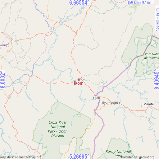
Ikom GPS coordinates[2]
5° 58' 0.084" North, 8° 42' 22.752" East
| Map corner | latitude | longitude |
|---|---|---|
| Upper-left | 6.66554°, | 8.0032° |
| Center: | 5.96669°, | 8.70632° |
| Lower-right: | 5.26695°, | 9.40945° |
| Map W x H: | 155.5×155.5 km | = 96.6×96.6mi |
| max Lat: | 13.7543° ⇑84.2% North |
| Ikom: | 5.96669° |
| min Lat: | ⇓15.8% South 4.31231° |
| min Long | Ikom | max Long |
| 2.73333° | 8.70632° | 14.46552° |
| W 73.8%⇐ | ⇒26.2% E |
Elevation
Elevation of Ikom is 60 m = 197 ft, and this is 236.5 m = 776 ft below average elevation for this country.
| Max E: |
1599 m = 5246 ft | 84.2% |
| Avg. | 296.5 m = 973 ft | |
| Ikom | 60 m = 197 ft | |
Min E: |
2 m = 7 ft | 15.8% |
See also: Ikom elevation on elevation.city.
Geographical zone
Ikom is located in North Torrid zone (between Equator and Tropic of Cancer). Distance of Equator is 663.4 km =412.2 mi to South.| Distance of | km | miles | from Ikom |
|---|---|---|---|
| North Pole | 9343.6 | 5805.8 | to North |
| Arctic Circle | 6737.7 | 4186.6 | to North |
| Tropic Cancer | 1942.5 | 1207 | to North |
| Equator | 663.4 | 412.2 | to South |


Nearby cities:
15 places around Ikom: (largest is in red/bold)
• Abakaliki
76.7 km =47.7 mi,  301°
301°
• Abuochiche
84.7 km =52.6 mi,  18°
18°
• Afikpo
85.7 km =53.3 mi,  264°
264°
• Akamkpa
82.5 km =51.3 mi,  208°
208°
• Akpet Central
77.1 km =47.9 mi,  240°
240°
• Boje
42.5 km =26.4 mi,  33°
33°
• Effraya
12.1 km =7.5 mi,  171°
171°
• Iboko
71.6 km =44.5 mi,  313°
313°
• Itigidi
76.2 km =47.3 mi, 263°
• Obubra
43.1 km =26.8 mi,  286°
286°
• Ogoja
77.6 km =48.2 mi,  7°
7°
• Okpoma
70.5 km =43.8 mi,  353°
353°
• Onuebonyi Echara
63 km =39.1 mi,  283°
283°
• Onueke
76.9 km =47.8 mi, 285°
• Ugep
71.4 km =44.4 mi, 255°
Sources, notices
• [Note1] Compared only with cities in Nigeria existing in our database
• [Src1] Map data: © OpenStreetMap contributors (CC-BY-SA)
• [Src2] Other city data from geonames.org with taken over terms of usage.
• [Src3] Geographical zone / Annual Mean Temperature by Robert A. Rohde @ Wikipedia
