Malumfashi geodata
Malumfashi (Katsina) is a seat of a second-order administrative division; located in Nigeria in Africa/Lagos (GMT+1) time zone. With population of 70,709 people, there are 134 cities with bigger population in this country. Compared to other cities in Nigeria, 81.9% of cities are located further ↓South; 55.8% of cities are located further ←West and 93.8% of cities have lower elevation than Malumfashi. Note1


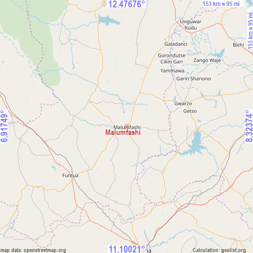
Malumfashi GPS coordinates[2]
11° 47' 21.66" North, 7° 37' 14.196" East
| Map corner | latitude | longitude |
|---|---|---|
| Upper-left | 12.47676°, | 6.91749° |
| Center: | 11.78935°, | 7.62061° |
| Lower-right: | 11.10021°, | 8.32374° |
| Map W x H: | 153.1×153.1 km | = 95.1×95.1mi |
| max Lat: | 13.7543° ⇑18.1% North |
| Malumfashi: | 11.78935° |
| min Lat: | ⇓81.9% South 4.31231° |
| min Long | Malumfashi | max Long |
| 2.73333° | 7.62061° | 14.46552° |
| W 55.8%⇐ | ⇒44.2% E |
Elevation
Elevation of Malumfashi is 618 m = 2028 ft, and this is 321.5 m = 1055 ft above average elevation for this country.
| Max E: |
1599 m = 5246 ft | 6.2% |
| Malumfashi | 618 m 2028 ft | |
| Avg. | 296.5 m = 973 ft | |
Min E: |
2 m = 7 ft | 93.8% |
See also: Malumfashi elevation on elevation.city.
Geographical zone
Malumfashi is located in North Torrid zone (between Equator and Tropic of Cancer). Distance of this Northern Tropic circle is 1295.1 km =804.7 mi to North.| Distance of | km | miles | from Malumfashi |
|---|---|---|---|
| North Pole | 8696.2 | 5403.6 | to North |
| Arctic Circle | 6090.3 | 3784.3 | to North |
| Tropic Cancer | 1295.1 | 804.7 | to North |
| Equator | 1310.9 | 814.6 | to South |


Nearby cities:
15 places around Malumfashi: (largest is in red/bold)
• Bakori
33.7 km =20.9 mi,  219°
219°
• Danja
46.3 km =28.8 mi,  188°
188°
• Funtua
44.8 km =27.8 mi,  228°
228°
• Giwa
55.9 km =34.7 mi,  199°
199°
• Gora
14.6 km =9.1 mi,  19°
19°
• Gwarzo
36.9 km =22.9 mi,  67°
67°
• Jikamshi
45.8 km =28.5 mi, 21°
• Kafur
17.7 km =11 mi,  154°
154°
• Kankara
27.7 km =17.2 mi,  304°
304°
• Karaye
42.9 km =26.7 mi,  90°
90°
• Makarfi
53.9 km =33.5 mi, 148°
• Matazu
49.9 km =31 mi,  6°
6°
• Musawa
38.2 km =23.7 mi, 8°
• Rogo
34.3 km =21.3 mi,  140°
140°
• Shanono
49.8 km =30.9 mi,  54°
54°
Sources, notices
• [Note1] Compared only with cities in Nigeria existing in our database
• [Src1] Map data: © OpenStreetMap contributors (CC-BY-SA)
• [Src2] Other city data from geonames.org with taken over terms of usage.
• [Src3] Geographical zone / Annual Mean Temperature by Robert A. Rohde @ Wikipedia
