Zaria geodata
Zaria (Kaduna) is a populated place; located in Nigeria in Africa/Lagos (GMT+1) time zone. With population of 975,153 people, there are 7 cities with bigger population in this country. Compared to other cities in Nigeria, 73.5% of cities are located further ↓South; 58.5% of cities are located further ←West and 94.3% of cities have lower elevation than Zaria. Note1


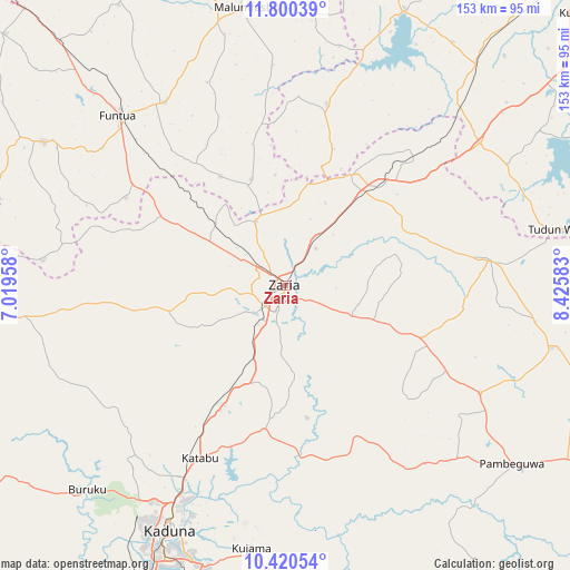
Zaria GPS coordinates[2]
11° 6' 40.608" North, 7° 43' 21.72" East
| Map corner | latitude | longitude |
|---|---|---|
| Upper-left | 11.80039°, | 7.01958° |
| Center: | 11.11128°, | 7.7227° |
| Lower-right: | 10.42054°, | 8.42583° |
| Map W x H: | 153.4×153.4 km | = 95.3×95.3mi |
| max Lat: | 13.7543° ⇑26.5% North |
| Zaria: | 11.11128° |
| min Lat: | ⇓73.5% South 4.31231° |
| min Long | Zaria | max Long |
| 2.73333° | 7.7227° | 14.46552° |
| W 58.5%⇐ | ⇒41.5% E |
Elevation
Elevation of Zaria is 644 m = 2113 ft, and this is 347.5 m = 1140 ft above average elevation for this country.
| Max E: |
1599 m = 5246 ft | 5.7% |
| Zaria | 644 m 2113 ft | |
| Avg. | 296.5 m = 973 ft | |
Min E: |
2 m = 7 ft | 94.3% |
See also: Zaria elevation on elevation.city.
Geographical zone
Zaria is located in North Torrid zone (between Equator and Tropic of Cancer). Distance of Equator is 1235.5 km =767.7 mi to South.| Distance of | km | miles | from Zaria |
|---|---|---|---|
| North Pole | 8771.6 | 5450.4 | to North |
| Arctic Circle | 6165.7 | 3831.2 | to North |
| Tropic Cancer | 1370.5 | 851.6 | to North |
| Equator | 1235.5 | 767.7 | to South |


Nearby cities:
15 places around Zaria: (largest is in red/bold)
• Bakori
59.2 km =36.8 mi,  326°
326°
• Dan Gora
66.4 km =41.3 mi,  44°
44°
• Danja
34.4 km =21.4 mi, 329°
• Dutsen Wai
59.6 km =37 mi,  119°
119°
• Funtua
64.1 km =39.8 mi,  315°
315°
• Giwa
37.5 km =23.3 mi,  307°
307°
• Hunkuyi
19.1 km =11.9 mi,  335°
335°
• Igabi
34 km =21.1 mi,  181°
181°
• Ikara
55.2 km =34.3 mi,  82°
82°
• Kafur
59.5 km =37 mi,  356°
356°
• Maigana
25.3 km =15.7 mi,  111°
111°
• Makarfi
34.3 km =21.3 mi,  30°
30°
• Rogo
50.2 km =31.2 mi,  12°
12°
• Sabuwa
66 km =41 mi,  276°
276°
• Soba
39.3 km =24.4 mi, 111°
Sources, notices
• [Note1] Compared only with cities in Nigeria existing in our database
• [Src1] Map data: © OpenStreetMap contributors (CC-BY-SA)
• [Src2] Other city data from geonames.org with taken over terms of usage.
• [Src3] Geographical zone / Annual Mean Temperature by Robert A. Rohde @ Wikipedia
