Kafur geodata
Kafur (Katsina) is a seat of a second-order administrative division; located in Nigeria in Africa/Lagos (GMT+1) time zone. In our database, there are 451 cities with bigger population. Compared to other cities in Nigeria, 79.1% of cities are located further ↓South; 57.6% of cities are located further ←West and 92.4% of cities have lower elevation than Kafur. Note1


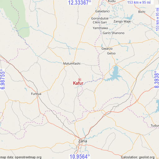
Kafur GPS coordinates[2]
11° 38' 45.204" North, 7° 41' 26.448" East
| Map corner | latitude | longitude |
|---|---|---|
| Upper-left | 12.33367°, | 6.98755° |
| Center: | 11.64589°, | 7.69068° |
| Lower-right: | 10.9564°, | 8.3938° |
| Map W x H: | 153.1×153.1 km | = 95.1×95.1mi |
| max Lat: | 13.7543° ⇑20.9% North |
| Kafur: | 11.64589° |
| min Lat: | ⇓79.1% South 4.31231° |
| min Long | Kafur | max Long |
| 2.73333° | 7.69068° | 14.46552° |
| W 57.6%⇐ | ⇒42.4% E |
Elevation
Elevation of Kafur is 587 m = 1926 ft, and this is 290.5 m = 953 ft above average elevation for this country.
| Max E: |
1599 m = 5246 ft | 7.6% |
| Kafur | 587 m 1926 ft | |
| Avg. | 296.5 m = 973 ft | |
Min E: |
2 m = 7 ft | 92.4% |
See also: Nigeria elevation on elevation.city.
Geographical zone
Kafur is located in North Torrid zone (between Equator and Tropic of Cancer). Distance of Equator is 1294.9 km =804.6 mi to South.| Distance of | km | miles | from Kafur |
|---|---|---|---|
| North Pole | 8712.2 | 5413.5 | to North |
| Arctic Circle | 6106.3 | 3794.3 | to North |
| Tropic Cancer | 1311 | 814.6 | to North |
| Equator | 1294.9 | 804.6 | to South |


Nearby cities:
15 places around Kafur: (largest is in red/bold)
• Bakori
30.7 km =19.1 mi,  250°
250°
• Dan Gora
51.8 km =32.2 mi,  103°
103°
• Danja
33.1 km =20.6 mi,  205°
205°
• Funtua
43.5 km =27 mi, 251°
• Giwa
45.1 km =28 mi,  215°
215°
• Gora
29.8 km =18.5 mi,  354°
354°
• Gwarzo
40 km =24.9 mi,  41°
41°
• Hunkuyi
42.4 km =26.3 mi,  186°
186°
• Kankara
44 km =27.3 mi,  316°
316°
• Karaye
38.5 km =23.9 mi,  66°
66°
• Kiru
48.8 km =30.3 mi,  82°
82°
• Makarfi
36.4 km =22.6 mi,  145°
145°
• Malumfashi
17.7 km =11 mi,  334°
334°
• Musawa
53.8 km =33.4 mi,  357°
357°
• Rogo
17.7 km =11 mi,  125°
125°
Sources, notices
• [Note1] Compared only with cities in Nigeria existing in our database
• [Src1] Map data: © OpenStreetMap contributors (CC-BY-SA)
• [Src2] Other city data from geonames.org with taken over terms of usage.
• [Src3] Geographical zone / Annual Mean Temperature by Robert A. Rohde @ Wikipedia
