Kuta geodata
Kuta (Niger) is a seat of a second-order administrative division; located in Nigeria in Africa/Lagos (GMT+1) time zone. With population of 7,528 people, there are 396 cities with bigger population in this country. Compared to other cities in Nigeria, 62.8% of cities are located further ↓South; 62.3% of cities are located further →East and 56% of cities have lower elevation than Kuta. Note1


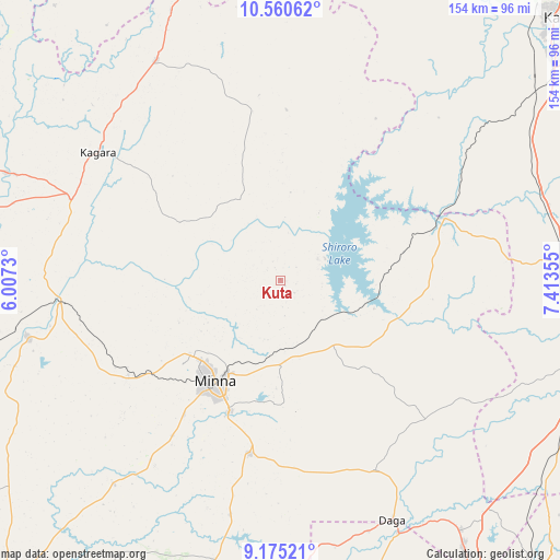
Kuta GPS coordinates[2]
9° 52' 7.104" North, 6° 42' 37.512" East
| Map corner | latitude | longitude |
|---|---|---|
| Upper-left | 10.56062°, | 6.0073° |
| Center: | 9.86864°, | 6.71042° |
| Lower-right: | 9.17521°, | 7.41355° |
| Map W x H: | 154×154 km | = 95.7×95.7mi |
| max Lat: | 13.7543° ⇑37.2% North |
| Kuta: | 9.86864° |
| min Lat: | ⇓62.8% South 4.31231° |
| min Long | Kuta | max Long |
| 2.73333° | 6.71042° | 14.46552° |
| W 37.7%⇐ | ⇒62.3% E |
Elevation
Elevation of Kuta is 318 m = 1043 ft, and this is 21.5 m = 71 ft above average elevation for this country.
| Max E: |
1599 m = 5246 ft | 44% |
| Kuta | 318 m 1043 ft | |
| Avg. | 296.5 m = 973 ft | |
Min E: |
2 m = 7 ft | 56% |
See also: Nigeria elevation on elevation.city.
Geographical zone
Kuta is located in North Torrid zone (between Equator and Tropic of Cancer). Distance of Equator is 1097.3 km =681.8 mi to South.| Distance of | km | miles | from Kuta |
|---|---|---|---|
| North Pole | 8909.8 | 5536.3 | to North |
| Arctic Circle | 6303.9 | 3917.1 | to North |
| Tropic Cancer | 1508.6 | 937.4 | to North |
| Equator | 1097.3 | 681.8 | to South |


Nearby cities:
15 places around Kuta: (largest is in red/bold)
• Birnin Gwari
90.4 km =56.2 mi,  348°
348°
• Gawu Babangida
72.6 km =45.1 mi,  154°
154°
• Kagara
61.1 km =38 mi,  305°
305°
• Kusheriki
79.5 km =49.4 mi,  338°
338°
• Lapai
92.9 km =57.7 mi,  189°
189°
• Lemu
91.4 km =56.8 mi,  234°
234°
• Maikunkele
32.6 km =20.3 mi, 231°
• Minna
33.3 km =20.7 mi,  212°
212°
• Paiko
48.7 km =30.3 mi, 189°
• Sabon Wuse
84.7 km =52.6 mi,  134°
134°
• Sarkin Pawa
47.2 km =29.3 mi,  68°
68°
• Suleja
92.2 km =57.3 mi, 146°
• Tegina
61.2 km =38 mi,  291°
291°
• Wushishi
71.5 km =44.4 mi,  257°
257°
• Zungeru
61.5 km =38.2 mi, 263°
Sources, notices
• [Note1] Compared only with cities in Nigeria existing in our database
• [Src1] Map data: © OpenStreetMap contributors (CC-BY-SA)
• [Src2] Other city data from geonames.org with taken over terms of usage.
• [Src3] Geographical zone / Annual Mean Temperature by Robert A. Rohde @ Wikipedia
