Ijebu-Jesa geodata
Ijebu-Jesa (Osun) is a seat of a second-order administrative division; located in Nigeria in Africa/Lagos (GMT+1) time zone. With population of 51,730 people, there are 146 cities with bigger population in this country. Compared to other cities in Nigeria, 58% of cities are located further ↑North; 83.8% of cities are located further →East and 81.1% of cities have lower elevation than Ijebu-Jesa. Note1


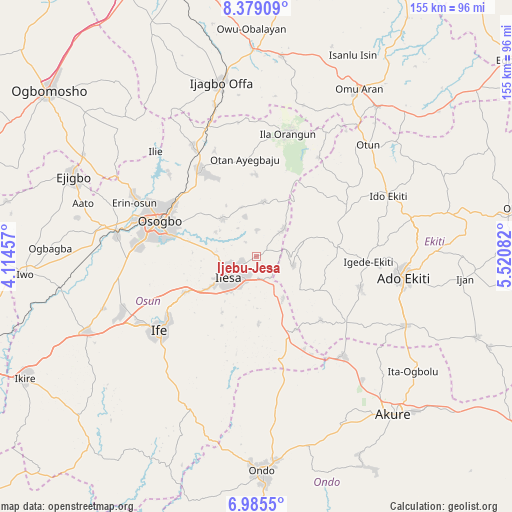
Ijebu-Jesa GPS coordinates[2]
7° 40' 58.332" North, 4° 49' 3.684" East
| Map corner | latitude | longitude |
|---|---|---|
| Upper-left | 8.37909°, | 4.11457° |
| Center: | 7.68287°, | 4.81769° |
| Lower-right: | 6.9855°, | 5.52082° |
| Map W x H: | 155×155 km | = 96.3×96.3mi |
| max Lat: | 13.7543° ⇑58% North |
| Ijebu-Jesa: | 7.68287° |
| min Lat: | ⇓42% South 4.31231° |
| min Long | Ijebu-Jesa | max Long |
| 2.73333° | 4.81769° | 14.46552° |
| W 16.2%⇐ | ⇒83.8% E |
Elevation
Elevation of Ijebu-Jesa is 477 m = 1565 ft, and this is 180.5 m = 592 ft above average elevation for this country.
| Max E: |
1599 m = 5246 ft | 18.9% |
| Ijebu-Jesa | 477 m 1565 ft | |
| Avg. | 296.5 m = 973 ft | |
Min E: |
2 m = 7 ft | 81.1% |
See also: Ijebu-Jesa elevation on elevation.city.
Geographical zone
Ijebu-Jesa is located in North Torrid zone (between Equator and Tropic of Cancer). Distance of Equator is 854.3 km =530.8 mi to South.| Distance of | km | miles | from Ijebu-Jesa |
|---|---|---|---|
| North Pole | 9152.8 | 5687.3 | to North |
| Arctic Circle | 6546.9 | 4068.1 | to North |
| Tropic Cancer | 1751.7 | 1088.5 | to North |
| Equator | 854.3 | 530.8 | to South |


Nearby cities:
15 places around Ijebu-Jesa: (largest is in red/bold)
• Aramoko-Ekiti
24.7 km =15.3 mi,  84°
84°
• Efon-Alaaye
11.9 km =7.4 mi,  104°
104°
• Ibokun
15.1 km =9.4 mi,  320°
320°
• Igbara-Odo
33.6 km =20.9 mi,  126°
126°
• Igede-Ekiti
34 km =21.1 mi,  92°
92°
• Ijero-Ekiti
31.2 km =19.4 mi,  61°
61°
• Ikirun
30.5 km =19 mi,  327°
327°
• Ilawe-Ekiti
33 km =20.5 mi,  106°
106°
• Ilesa
10.4 km =6.5 mi,  233°
233°
• Iperindo
20.1 km =12.5 mi,  177°
177°
• Iragbiji
28.5 km =17.7 mi, 329°
• Oke Mesi
18.4 km =11.4 mi,  36°
36°
• Osogbo
30.4 km =18.9 mi,  288°
288°
• Osu
24.1 km =15 mi,  243°
243°
• Otan Ayegbaju
29.6 km =18.4 mi,  353°
353°
Sources, notices
• [Note1] Compared only with cities in Nigeria existing in our database
• [Src1] Map data: © OpenStreetMap contributors (CC-BY-SA)
• [Src2] Other city data from geonames.org with taken over terms of usage.
• [Src3] Geographical zone / Annual Mean Temperature by Robert A. Rohde @ Wikipedia
