Odoro Ikpe geodata
Odoro Ikpe (Akwa Ibom) is a seat of a second-order administrative division; located in Nigeria in Africa/Lagos (GMT+1) time zone. In our database, there are 451 cities with bigger population. Compared to other cities in Nigeria, 90.9% of cities are located further ↑North; 59% of cities are located further ←West and 74.8% of cities have higher elevation than Odoro Ikpe. Note1


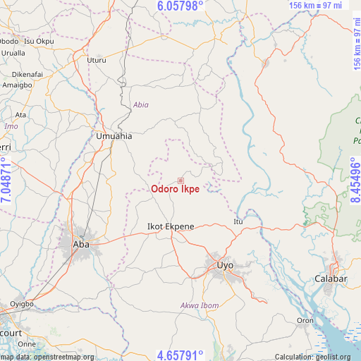
Odoro Ikpe GPS coordinates[2]
5° 21' 30.06" North, 7° 45' 6.624" East
| Map corner | latitude | longitude |
|---|---|---|
| Upper-left | 6.05798°, | 7.04871° |
| Center: | 5.35835°, | 7.75184° |
| Lower-right: | 4.65791°, | 8.45496° |
| Map W x H: | 155.7×155.7 km | = 96.7×96.7mi |
| max Lat: | 13.7543° ⇑90.9% North |
| Odoro Ikpe: | 5.35835° |
| min Lat: | ⇓9.1% South 4.31231° |
| min Long | Odoro Ikpe | max Long |
| 2.73333° | 7.75184° | 14.46552° |
| W 59%⇐ | ⇒41% E |
Elevation
Elevation of Odoro Ikpe is 121 m = 397 ft, and this is 175.5 m = 576 ft below average elevation for this country.
| Max E: |
1599 m = 5246 ft | 74.8% |
| Avg. | 296.5 m = 973 ft | |
| Odoro Ikpe | 121 m = 397 ft | |
Min E: |
2 m = 7 ft | 25.2% |
See also: Nigeria elevation on elevation.city.
Geographical zone
Odoro Ikpe is located in North Torrid zone (between Equator and Tropic of Cancer). Distance of Equator is 595.8 km =370.2 mi to South.| Distance of | km | miles | from Odoro Ikpe |
|---|---|---|---|
| North Pole | 9411.3 | 5847.9 | to North |
| Arctic Circle | 6805.4 | 4228.7 | to North |
| Tropic Cancer | 2010.1 | 1249 | to North |
| Equator | 595.8 | 370.2 | to South |


Nearby cities:
15 places around Odoro Ikpe: (largest is in red/bold)
• Afaha Ikot Ebak
28 km =17.4 mi,  202°
202°
• Arochukwu
18.1 km =11.2 mi,  79°
79°
• Bende
25.8 km =16 mi,  329°
329°
• Ebem Ohafia
31.5 km =19.6 mi,  15°
15°
• Ibiaku Ntok Okpo
7.1 km =4.4 mi,  219°
219°
• Ikot Ekpene
20 km =12.4 mi,  191°
191°
• Isiala Oboro
21 km =13 mi,  284°
284°
• Itu
31 km =19.3 mi,  124°
124°
• Nto Edino
22.5 km =14 mi,  239°
239°
• Ohafia-Ifigh
29.3 km =18.2 mi,  13°
13°
• Oko Ita
24.4 km =15.2 mi,  139°
139°
• Okpuala-Ngwa
40.3 km =25 mi,  269°
269°
• Omoba
40.4 km =25.1 mi,  251°
251°
• Umuahia
34 km =21.1 mi,  303°
303°
• Uyo
39.6 km =24.6 mi,  149°
149°
Sources, notices
• [Note1] Compared only with cities in Nigeria existing in our database
• [Src1] Map data: © OpenStreetMap contributors (CC-BY-SA)
• [Src2] Other city data from geonames.org with taken over terms of usage.
• [Src3] Geographical zone / Annual Mean Temperature by Robert A. Rohde @ Wikipedia
