Nnewi geodata
Nnewi (Anambra) is a seat of a second-order administrative division; located in Nigeria in Africa/Lagos (GMT+1) time zone. With population of 193,987 people, there are 46 cities with bigger population in this country. Compared to other cities in Nigeria, 83.4% of cities are located further ↑North; 58.7% of cities are located further →East and 69.5% of cities have higher elevation than Nnewi. Note1


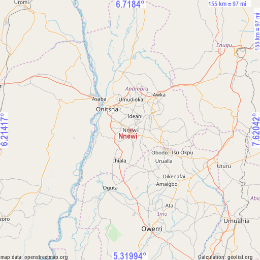
Nnewi GPS coordinates[2]
6° 1' 10.632" North, 6° 55' 2.244" East
| Map corner | latitude | longitude |
|---|---|---|
| Upper-left | 6.7184°, | 6.21417° |
| Center: | 6.01962°, | 6.91729° |
| Lower-right: | 5.31994°, | 7.62042° |
| Map W x H: | 155.5×155.5 km | = 96.6×96.6mi |
| max Lat: | 13.7543° ⇑83.4% North |
| Nnewi: | 6.01962° |
| min Lat: | ⇓16.6% South 4.31231° |
| min Long | Nnewi | max Long |
| 2.73333° | 6.91729° | 14.46552° |
| W 41.3%⇐ | ⇒58.7% E |
Elevation
Elevation of Nnewi is 151 m = 495 ft, and this is 145.5 m = 477 ft below average elevation for this country.
| Max E: |
1599 m = 5246 ft | 69.5% |
| Avg. | 296.5 m = 973 ft | |
| Nnewi | 151 m = 495 ft | |
Min E: |
2 m = 7 ft | 30.5% |
See also: Nnewi elevation on elevation.city.
Geographical zone
Nnewi is located in North Torrid zone (between Equator and Tropic of Cancer). Distance of Equator is 669.3 km =415.9 mi to South.| Distance of | km | miles | from Nnewi |
|---|---|---|---|
| North Pole | 9337.7 | 5802.2 | to North |
| Arctic Circle | 6731.9 | 4183 | to North |
| Tropic Cancer | 1936.6 | 1203.3 | to North |
| Equator | 669.3 | 415.9 | to South |


Nearby cities:
15 places around Nnewi: (largest is in red/bold)
• Aguata
18.9 km =11.7 mi,  91°
91°
• Agulu
18.3 km =11.4 mi,  60°
60°
• Atani
18.8 km =11.7 mi,  267°
267°
• Enugu-Ukwu
19.5 km =12.1 mi,  29°
29°
• Igbo-Ukwu
11.4 km =7.1 mi, 90°
• Ihiala
19.4 km =12.1 mi,  199°
199°
• Neni
14.5 km =9 mi,  54°
54°
• Nkpor
17.4 km =10.8 mi,  326°
326°
• Ogidi
15.9 km =9.9 mi,  337°
337°
• Ojoto
7.6 km =4.7 mi,  304°
304°
• Onitsha
20.5 km =12.7 mi,  314°
314°
• Ozubulu
9.9 km =6.2 mi,  225°
225°
• Uga
20.2 km =12.6 mi,  117°
117°
• Ukpor
8.7 km =5.4 mi,  171°
171°
• Uruobo-Okija
15.6 km =9.7 mi,  211°
211°
Sources, notices
• [Note1] Compared only with cities in Nigeria existing in our database
• [Src1] Map data: © OpenStreetMap contributors (CC-BY-SA)
• [Src2] Other city data from geonames.org with taken over terms of usage.
• [Src3] Geographical zone / Annual Mean Temperature by Robert A. Rohde @ Wikipedia
