Ugwolawo geodata
Ugwolawo (Kogi) is a seat of a second-order administrative division; located in Nigeria in Africa/Lagos (GMT+1) time zone. In our database, there are 451 cities with bigger population. Compared to other cities in Nigeria, 65.4% of cities are located further ↑North; 58.3% of cities are located further →East and 75.8% of cities have higher elevation than Ugwolawo. Note1


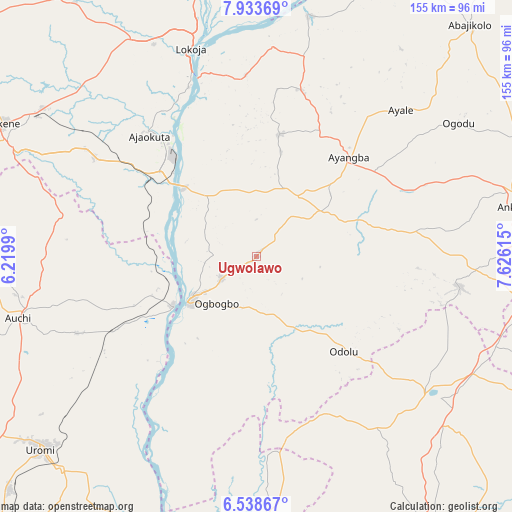
Ugwolawo GPS coordinates[2]
7° 14' 12.192" North, 6° 55' 22.872" East
| Map corner | latitude | longitude |
|---|---|---|
| Upper-left | 7.93369°, | 6.2199° |
| Center: | 7.23672°, | 6.92302° |
| Lower-right: | 6.53867°, | 7.62615° |
| Map W x H: | 155.1×155.1 km | = 96.4×96.4mi |
| max Lat: | 13.7543° ⇑65.4% North |
| Ugwolawo: | 7.23672° |
| min Lat: | ⇓34.6% South 4.31231° |
| min Long | Ugwolawo | max Long |
| 2.73333° | 6.92302° | 14.46552° |
| W 41.7%⇐ | ⇒58.3% E |
Elevation
Elevation of Ugwolawo is 114 m = 374 ft, and this is 182.5 m = 599 ft below average elevation for this country.
| Max E: |
1599 m = 5246 ft | 75.8% |
| Avg. | 296.5 m = 973 ft | |
| Ugwolawo | 114 m = 374 ft | |
Min E: |
2 m = 7 ft | 24.2% |
See also: Nigeria elevation on elevation.city.
Geographical zone
Ugwolawo is located in North Torrid zone (between Equator and Tropic of Cancer). Distance of Equator is 804.6 km =500 mi to South.| Distance of | km | miles | from Ugwolawo |
|---|---|---|---|
| North Pole | 9202.4 | 5718.1 | to North |
| Arctic Circle | 6596.5 | 4098.9 | to North |
| Tropic Cancer | 1801.3 | 1119.3 | to North |
| Equator | 804.6 | 500 | to South |


Nearby cities:
15 places around Ugwolawo: (largest is in red/bold)
• Abocho
37.5 km =23.3 mi,  10°
10°
• Adani
56.1 km =34.9 mi,  170°
170°
• Adogo
57.6 km =35.8 mi,  301°
301°
• Adoru
39.2 km =24.4 mi,  137°
137°
• Agenebode
29.2 km =18.1 mi,  239°
239°
• Ajaka
12.8 km =8 mi, 237°
• Ajaokuta
46.7 km =29 mi,  320°
320°
• Dekina
52.1 km =32.4 mi, 14°
• Ete
60.8 km =37.8 mi,  105°
105°
• Fugar
49.6 km =30.8 mi,  250°
250°
• Ibagwa-Aka
63.3 km =39.3 mi,  123°
123°
• Icheu
54.9 km =34.1 mi,  342°
342°
• Idah
24.5 km =15.2 mi, 236°
• Ogurugu
50.2 km =31.2 mi,  176°
176°
• Onyedega
47.9 km =29.8 mi,  214°
214°
Sources, notices
• [Note1] Compared only with cities in Nigeria existing in our database
• [Src1] Map data: © OpenStreetMap contributors (CC-BY-SA)
• [Src2] Other city data from geonames.org with taken over terms of usage.
• [Src3] Geographical zone / Annual Mean Temperature by Robert A. Rohde @ Wikipedia
