Numan geodata
Numan (Adamawa) is a seat of a second-order administrative division; located in Nigeria in Africa/Lagos (GMT+1) time zone. With population of 77,617 people, there are 117 cities with bigger population in this country. Compared to other cities in Nigeria, 59.3% of cities are located further ↓South; 93.9% of cities are located further ←West and 67.2% of cities have higher elevation than Numan. Note1


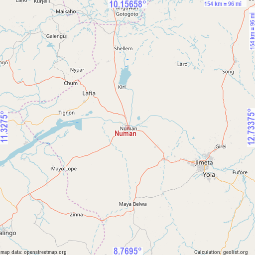
Numan GPS coordinates[2]
9° 27' 49.464" North, 12° 1' 50.232" East
| Map corner | latitude | longitude |
|---|---|---|
| Upper-left | 10.15658°, | 11.3275° |
| Center: | 9.46374°, | 12.03062° |
| Lower-right: | 8.7695°, | 12.73375° |
| Map W x H: | 154.2×154.2 km | = 95.8×95.8mi |
| max Lat: | 13.7543° ⇑40.7% North |
| Numan: | 9.46374° |
| min Lat: | ⇓59.3% South 4.31231° |
| min Long | Numan | max Long |
| 2.73333° | 12.03062° | 14.46552° |
| W 93.9%⇐ | ⇒6.1% E |
Elevation
Elevation of Numan is 161 m = 528 ft, and this is 135.5 m = 445 ft below average elevation for this country.
| Max E: |
1599 m = 5246 ft | 67.2% |
| Avg. | 296.5 m = 973 ft | |
| Numan | 161 m = 528 ft | |
Min E: |
2 m = 7 ft | 32.8% |
See also: Numan elevation on elevation.city.
Geographical zone
Numan is located in North Torrid zone (between Equator and Tropic of Cancer). Distance of Equator is 1052.3 km =653.9 mi to South.| Distance of | km | miles | from Numan |
|---|---|---|---|
| North Pole | 8954.8 | 5564.3 | to North |
| Arctic Circle | 6348.9 | 3945 | to North |
| Tropic Cancer | 1553.6 | 965.4 | to North |
| Equator | 1052.3 | 653.9 | to South |


Nearby cities:
15 places around Numan: (largest is in red/bold)
• Dadiya
67.7 km =42.1 mi,  284°
284°
• Demsa
13.4 km =8.3 mi,  93°
93°
• Fufore
73.1 km =45.4 mi,  111°
111°
• Girei
57.6 km =35.8 mi,  100°
100°
• Guyuk
50.5 km =31.4 mi,  347°
347°
• Jada
79.8 km =49.6 mi,  170°
170°
• Jimeta
51.2 km =31.8 mi, 113°
• Lamurde
30.6 km =19 mi,  301°
301°
• Mayo-Belwa
45.6 km =28.3 mi,  176°
176°
• Ngurore
30.1 km =18.7 mi,  130°
130°
• Shelleng
48.2 km =30 mi,  356°
356°
• Song
76.5 km =47.5 mi,  58°
58°
• Talasse
68 km =42.3 mi,  325°
325°
• Yola
57 km =35.4 mi,  119°
119°
• Zing
61.1 km =38 mi,  210°
210°
Sources, notices
• [Note1] Compared only with cities in Nigeria existing in our database
• [Src1] Map data: © OpenStreetMap contributors (CC-BY-SA)
• [Src2] Other city data from geonames.org with taken over terms of usage.
• [Src3] Geographical zone / Annual Mean Temperature by Robert A. Rohde @ Wikipedia
