Demsa geodata
Demsa (Adamawa) is a seat of a second-order administrative division; located in Nigeria in Africa/Lagos (GMT+1) time zone. In our database, there are 451 cities with bigger population. Compared to other cities in Nigeria, 59.1% of cities are located further ↓South; 94.7% of cities are located further ←West and 69% of cities have higher elevation than Demsa. Note1


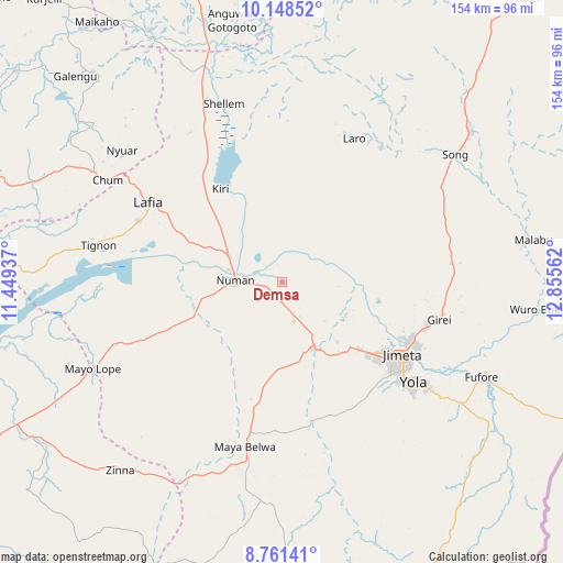
Demsa GPS coordinates[2]
9° 27' 20.376" North, 12° 9' 8.964" East
| Map corner | latitude | longitude |
|---|---|---|
| Upper-left | 10.14852°, | 11.44937° |
| Center: | 9.45566°, | 12.15249° |
| Lower-right: | 8.76141°, | 12.85562° |
| Map W x H: | 154.2×154.2 km | = 95.8×95.8mi |
| max Lat: | 13.7543° ⇑40.9% North |
| Demsa: | 9.45566° |
| min Lat: | ⇓59.1% South 4.31231° |
| min Long | Demsa | max Long |
| 2.73333° | 12.15249° | 14.46552° |
| W 94.7%⇐ | ⇒5.3% E |
Elevation
Elevation of Demsa is 152 m = 499 ft, and this is 144.5 m = 474 ft below average elevation for this country.
| Max E: |
1599 m = 5246 ft | 69% |
| Avg. | 296.5 m = 973 ft | |
| Demsa | 152 m = 499 ft | |
Min E: |
2 m = 7 ft | 31% |
See also: Nigeria elevation on elevation.city.
Geographical zone
Demsa is located in North Torrid zone (between Equator and Tropic of Cancer). Distance of Equator is 1051.4 km =653.3 mi to South.| Distance of | km | miles | from Demsa |
|---|---|---|---|
| North Pole | 8955.7 | 5564.8 | to North |
| Arctic Circle | 6349.8 | 3945.6 | to North |
| Tropic Cancer | 1554.5 | 965.9 | to North |
| Equator | 1051.4 | 653.3 | to South |


Nearby cities:
15 places around Demsa: (largest is in red/bold)
• Dadiya
80.9 km =50.3 mi,  282°
282°
• Fufore
60.4 km =37.5 mi,  115°
115°
• Girei
44.3 km =27.5 mi,  103°
103°
• Guyuk
55.9 km =34.7 mi,  333°
333°
• Jada
77.7 km =48.3 mi,  179°
179°
• Jimeta
38.8 km =24.1 mi, 120°
• Lamurde
42.9 km =26.7 mi,  293°
293°
• Mayo-Belwa
45.8 km =28.5 mi,  193°
193°
• Ngurore
20.9 km =13 mi,  152°
152°
• Numan
13.4 km =8.3 mi,  273°
273°
• Shelleng
51.6 km =32.1 mi,  341°
341°
• Song
66.1 km =41.1 mi,  51°
51°
• Talasse
77.1 km =47.9 mi,  317°
317°
• Yola
45.4 km =28.2 mi,  127°
127°
• Zing
68.2 km =42.4 mi,  220°
220°
Sources, notices
• [Note1] Compared only with cities in Nigeria existing in our database
• [Src1] Map data: © OpenStreetMap contributors (CC-BY-SA)
• [Src2] Other city data from geonames.org with taken over terms of usage.
• [Src3] Geographical zone / Annual Mean Temperature by Robert A. Rohde @ Wikipedia
