Yola geodata
Yola (Adamawa) is a seat of a first-order administrative division; located in Nigeria in Africa/Lagos (GMT+1) time zone. With population of 96,006 people, there are 89 cities with bigger population in this country. Compared to other cities in Nigeria, 56.8% of cities are located further ↓South; 95.7% of cities are located further ←West and 64.6% of cities have higher elevation than Yola. Note1


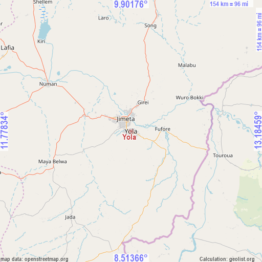
Yola GPS coordinates[2]
9° 12' 30.204" North, 12° 28' 53.256" East
| Map corner | latitude | longitude |
|---|---|---|
| Upper-left | 9.90176°, | 11.77834° |
| Center: | 9.20839°, | 12.48146° |
| Lower-right: | 8.51366°, | 13.18459° |
| Map W x H: | 154.3×154.3 km | = 95.9×95.9mi |
| max Lat: | 13.7543° ⇑43.2% North |
| Yola: | 9.20839° |
| min Lat: | ⇓56.8% South 4.31231° |
| min Long | Yola | max Long |
| 2.73333° | 12.48146° | 14.46552° |
| W 95.7%⇐ | ⇒4.3% E |
Elevation
Elevation of Yola is 180 m = 591 ft, and this is 116.5 m = 382 ft below average elevation for this country.
| Max E: |
1599 m = 5246 ft | 64.6% |
| Avg. | 296.5 m = 973 ft | |
| Yola | 180 m = 591 ft | |
Min E: |
2 m = 7 ft | 35.4% |
See also: Yola elevation on elevation.city.
Geographical zone
Yola is located in North Torrid zone (between Equator and Tropic of Cancer). Distance of Equator is 1023.9 km =636.2 mi to South.| Distance of | km | miles | from Yola |
|---|---|---|---|
| North Pole | 8983.2 | 5581.9 | to North |
| Arctic Circle | 6377.3 | 3962.7 | to North |
| Tropic Cancer | 1582 | 983 | to North |
| Equator | 1023.9 | 636.2 | to South |


Nearby cities:
15 places around Yola: (largest is in red/bold)
• Demsa
45.4 km =28.2 mi,  307°
307°
• Fufore
18.5 km =11.5 mi,  85°
85°
• Ganye
98.1 km =61 mi,  208°
208°
• Girei
18.8 km =11.7 mi,  22°
22°
• Guyuk
98.6 km =61.3 mi,  321°
321°
• Holma
99.2 km =61.6 mi,  39°
39°
• Jada
61.7 km =38.3 mi,  215°
215°
• Jimeta
8.3 km =5.2 mi,  342°
342°
• Lamurde
87.6 km =54.4 mi,  300°
300°
• Mayo-Belwa
49.6 km =30.8 mi,  249°
249°
• Ngurore
27.9 km =17.3 mi,  288°
288°
• Numan
57 km =35.4 mi, 299°
• Shelleng
92.6 km =57.5 mi,  325°
325°
• Song
70.5 km =43.8 mi,  12°
12°
• Zing
84.1 km =52.3 mi, 253°
Sources, notices
• [Note1] Compared only with cities in Nigeria existing in our database
• [Src1] Map data: © OpenStreetMap contributors (CC-BY-SA)
• [Src2] Other city data from geonames.org with taken over terms of usage.
• [Src3] Geographical zone / Annual Mean Temperature by Robert A. Rohde @ Wikipedia
